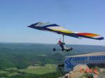
Pigeon Mountain, 350 Meter
          
Talort:
LaFayette
Höhe Talort:
240 Meter
Höhenunterschied:
110
Meter
Start Richtungen:
Seilbahn:
Nein
Streckenflug:
Nein
Soaring:
Keine Angabe
Windenschlepp:
Nein
Walk and Fly:
Nein
Ski and Fly:
Nein
Drachen:
Keine Angabe
UL:
Ja
GPS Tal:
Qualität Fluggebiet:
Qualität dieser Seite:
Statistik:
Adoption (User):
-
Zuletzt bearbeitet:
22.01.2006
He who likes beautiful forest flights, should not miss this long cliff in the State Park. There are diverse landing possibilities, normally one lands by the white house, just in front of the launch site. Alternatively there is also a field to the left at the end of the street. Both are also reachable without the large lift.
Bewertung der Fluggebiets- und der Seitenqualität
Flug
The numerous, fast and highly growing trees can be quickly get in the way, however if one can get away corretly there is XC-potential to reache the airport 20 miles away in Hammondville.
Wissenswertes
Anfahrt:
On the 75N take the second Resaca Exit (Highway 136), then over teh 136W to LaFayette. Follow the 193N a few miles until Chamberlain Road, and turn left. After 3,5 Miles you will come to a stone road to the right heading to Pigeon Mountain. Take this road und when you reach the fork contiune another 2 miles to the left and you will reach the launch site.
Download: Google Earth Dateien für Fluggebiet und Flugdaten (IGC, OLC)
Download: Google Earth Dateien (KML-Format), Flugdaten (IGC Format)
Die letzten 3 Flüge
Leider keine OLC Daten vorhanden.
Flugdaten von www.paraglidingforum.com
Leider keine OLC Daten von www.paraglidingforum.com vorhanden.
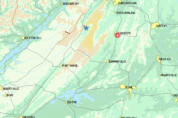
Umgebungskarte
  Fluggebiet  Flugschule  Aktuelle Position |
Fluggebiete in der Nähe (Radius: 50 km)
Nordamerika » USA » Georgia
Entfernung:
24 km
Höhenuntersch.:
397
Meter
Ort:
Rising Fawn
Streckenflug:
Nein
Startplatz:
mittel
Landeplatz:
mittel
Start Richtungen:

|
08.02.2005
|
 |
|
0 Votes
|
882 Hits
|
| [Oliver Voss] | | www.hanglide.com |
|
This 20 mile long mountain chain begins in the three croner edge of Georgia, Alabama, Tennesse. The site lies between the city Chattanooga and the Cloudland Canyon State Park, an area that is optically pleasing. Therefore not only because of its outstanding ramp, Lookout Mountain Flight park is...
Nordamerika » USA » Alabama
Entfernung:
36 km
Höhenuntersch.:
0
Meter
Ort:
Ider
Streckenflug:
Nein
Startplatz:
Keine Angabe
Landeplatz:
Keine Angabe
Start Richtungen:
A grass strip more than a kilometer in length offering ideal possibilities for towing. From Ider drive along the 117 fro approx. two miles in the northern direction, the strip is located on the right hand side, however is not visible from the road.
Flugschulen in der Nähe (Radius: 50 km)
Nordamerika » USA » Georgia
Geballte Flugerfahrung in Georgia: Der 'Lookout Mountain Flight Park' bildet seit 1978 Piloten aus. Hier könnt Ihr auch 'Utraleicht' fliegen.
Alle Fluggebiete und Flugschulen in der Nähe anzeigen
|