Observatory Point-Twilight Beach, Esperance, 200 Meter
          
Talort:
Albany
Höhe Talort:
84 Meter
Höhenunterschied:
0
Meter
Start Richtungen:
Seilbahn:
Nein
Streckenflug:
Ja
Soaring:
Keine Angabe
Windenschlepp:
Nein
Walk and Fly:
Nein
Ski and Fly:
Nein
Drachen:
Keine Angabe
UL:
Keine Angabe
Google Maps:
Qualität Fluggebiet:
Qualität dieser Seite:
Statistik:
Adoption (User):
-
Zuletzt bearbeitet:
15.12.2005
An absolutley amazing plain landscape perfect for dreaming and flying.
Bewertung der Fluggebiets- und der Seitenqualität
Flug
At this magnificent plain landscape, the possibility exists to land above at the starting point again. Please however take caution with the quickly freshening up lake breeze when landing.
Besonderheiten und Webcam
| The street leads directly up to the starting place. |
Wissenswertes
Anfahrt:
Located directly near Esperance, the site is well signed and easy to reach along the coastal street. The street leads up to the starting place.
Sonstiges:
Albany is 400km south of Perth. It is a large coastal region with all wind directions. It is know as one of the best flying locations in Western Australia if you want to spend a couple of crazy hours in the air.
Startplätze
Startplatz:
Observatory Point-Twilight Beach, Esperance
Startrichtung:

SO Schwierigkeit:
mittel
Höhe über NN:
200
|
Landeplätze
Landeplatz:
Observatory Point-Twilight Beach, Esperance
Schwierigkeit:
mittel
Höhe über NN:
200
|
Download: Google Earth Dateien für Fluggebiet und Flugdaten (IGC, OLC)
Download: Google Earth Dateien (KML-Format), Flugdaten (IGC Format)
Die letzten 3 Flüge
Leider keine OLC Daten vorhanden.
Flugdaten von www.paraglidingforum.com
Leider keine OLC Daten von www.paraglidingforum.com vorhanden.
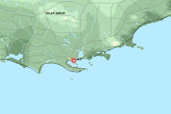
Umgebungskarte
  Fluggebiet  Flugschule  Aktuelle Position | Orte in der Nähe
Albany (2 km)
Green Island (6 km)
Cuthbert (8 km)
Seal Island (10 km)
King River (11 km)
Green Island (11 km)
Albany Aerodrome (12 km)
Grasmere (13 km)
Grassmere (13 km)
Stony Island (14 km)
Michaelmas Island (15 km)
Elleker (15 km)
Torbay Junction (15 km)
Breaksea Island (15 km)
Marbellup (16 km)
|
Fluggebiete in der Nähe (Radius: 50 km)
Australien / Ozeanien » Australien » Western Australia
Entfernung:
0 km
Höhenuntersch.:
-64
Meter
Ort:
Albany
Streckenflug:
Ja
Startplatz:
mittel
Landeplatz:
schwer
Start Richtungen:
In the heart of Albany you will get a great view of the site from the starting place Circumstance guarantees one orderly and quiet flight with a crazy look over the harbor, the city and Fort Adelaide.
Australien / Ozeanien » Australien » Western Australia
Entfernung:
0 km
Höhenuntersch.:
0
Meter
Ort:
Albany
Streckenflug:
Ja
Startplatz:
mittel
Landeplatz:
schwer
Start Richtungen:
Large site with over 10km long, strong falling away Front with no possibilities to land below, as the slope ends directly in the ocean.
Australien / Ozeanien » Australien » Western Australia
Entfernung:
0 km
Höhenuntersch.:
-59
Meter
Ort:
Albany
Streckenflug:
Nein
Startplatz:
sehr leicht
Landeplatz:
sehr leicht
Start Richtungen:
One of Western Australia's quietest and steadiest flight zones. Suited well for the beginner, for it always offers landing possibilities below on the beach.
The slight height of the dunes enables you to fly even in stong wind conditions.
Flugschulen in der Nähe (Radius: 50 km)
Australien / Ozeanien » Australien » Western Australia
Jeder ist willkommen, der ein mutiger Paraglider oder Drachenflieger werden will. Alles weitere auf Anfrage!
Alle Fluggebiete und Flugschulen in der Nähe anzeigen
|