Lowlands Beach, 35 Meter
          
Talort:
Albany
Höhe Talort:
84 Meter
Höhenunterschied:
-49
Meter
Start Richtungen:
Seilbahn:
Nein
Streckenflug:
Ja
Soaring:
Keine Angabe
Windenschlepp:
Nein
Walk and Fly:
Nein
Ski and Fly:
Nein
Drachen:
Keine Angabe
UL:
Keine Angabe
Google Maps:
Qualität Fluggebiet:
Qualität dieser Seite:
Statistik:
Adoption (User):
-
Zuletzt bearbeitet:
15.12.2005
You will find these high dunes between Albany and Denmark. It is perfectly positioned with the other flight zones in the vicinity, ie. Dingos or Shelleys, for stronger winds.
Bewertung der Fluggebiets- und der Seitenqualität
Flug
Generally speaking Lowlands Beach is a beach flying site with possibilites to start a Hang Glider above at the starting place. A lovely wide beach with sure landings.
Wissenswertes
Anfahrt:
Drive from Albany or the Shellez Beach Drive in the direction of Denmark via Denmark Roud E. Turn left on the Tevresee South Road. Continue on until you reach the parking area at the end of the street.
In the western direction you will find the coast. Alsoif you walk in the direction of the beach you will find a comfortable starting place.
Sonstiges:
Albany is 400km south of Perth. Albany ist 400km südlich von Perth. It is a large coastal region, with all wind directions. It's the best Flying location in Western Australia if you want to spend a couple of crazy hours in the air.
Startplätze
Startplatz:
Lowlands Beach
Startrichtung:

O SO Schwierigkeit:
leicht
Höhe über NN:
35
|
Landeplätze
Landeplatz:
Lowlands Beach
Schwierigkeit:
sehr leicht
Höhe über NN:
0
Der Strand kann zum landen genutzt werden.
|
Download: Google Earth Dateien für Fluggebiet und Flugdaten (IGC, OLC)
Download: Google Earth Dateien (KML-Format), Flugdaten (IGC Format)
Die letzten 3 Flüge
Leider keine OLC Daten vorhanden.
Flugdaten von www.paraglidingforum.com
Leider keine OLC Daten von www.paraglidingforum.com vorhanden.
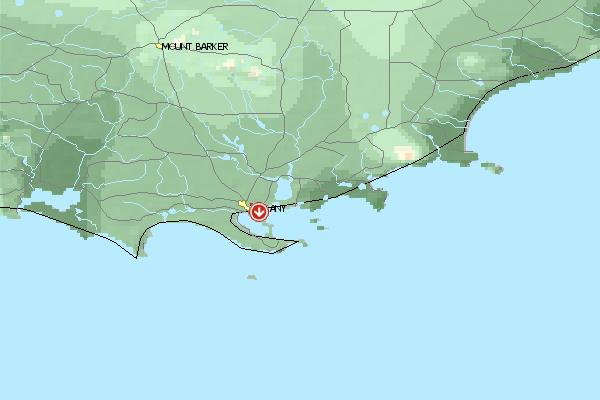
Umgebungskarte
  Fluggebiet  Flugschule  Aktuelle Position | Orte in der Nähe
Albany (2 km)
Green Island (6 km)
Cuthbert (8 km)
Seal Island (10 km)
King River (11 km)
Green Island (11 km)
Albany Aerodrome (12 km)
Grasmere (13 km)
Grassmere (13 km)
Stony Island (14 km)
Michaelmas Island (15 km)
Elleker (15 km)
Torbay Junction (15 km)
Breaksea Island (15 km)
Marbellup (16 km)
|
Fluggebiete in der Nähe (Radius: 50 km)
Australien / Ozeanien » Australien » Western Australia
Entfernung:
0 km
Höhenuntersch.:
-64
Meter
Ort:
Albany
Streckenflug:
Ja
Startplatz:
mittel
Landeplatz:
schwer
Start Richtungen:
In the heart of Albany you will get a great view of the site from the starting place Circumstance guarantees one orderly and quiet flight with a crazy look over the harbor, the city and Fort Adelaide.
Australien / Ozeanien » Australien » Western Australia
Entfernung:
0 km
Höhenuntersch.:
0
Meter
Ort:
Albany
Streckenflug:
Ja
Startplatz:
mittel
Landeplatz:
schwer
Start Richtungen:
Large site with over 10km long, strong falling away Front with no possibilities to land below, as the slope ends directly in the ocean.
Australien / Ozeanien » Australien » Western Australia
Entfernung:
0 km
Höhenuntersch.:
-59
Meter
Ort:
Albany
Streckenflug:
Nein
Startplatz:
sehr leicht
Landeplatz:
sehr leicht
Start Richtungen:
One of Western Australia's quietest and steadiest flight zones. Suited well for the beginner, for it always offers landing possibilities below on the beach.
The slight height of the dunes enables you to fly even in stong wind conditions.
Flugschulen in der Nähe (Radius: 50 km)
Australien / Ozeanien » Australien » Western Australia
Jeder ist willkommen, der ein mutiger Paraglider oder Drachenflieger werden will. Alles weitere auf Anfrage!
Alle Fluggebiete und Flugschulen in der Nähe anzeigen
|