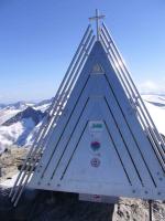
Dreiherrenspitze, 3498 Meter


Talort:
Kasern
Höhe Talort:
1500 Meter
Höhenunterschied:
1998
Meter
Start Richtungen:
Seilbahn:
Nein
Streckenflug:
Ja
Soaring:
Nein
Windenschlepp:
Nein
Walk and Fly:
Ja
Ski and Fly:
Ja
Drachen:
Nein
UL:
Keine Angabe
Qualität Fluggebiet:
Qualität dieser Seite:
Statistik:
Adoption (User):
Axel7 seit 05.09.2008
Zuletzt bearbeitet:
23.09.2008
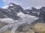
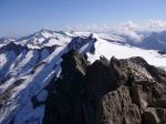
Dreiherrenspitze is a two day walk & fly from Kasern (leaving the car) in the Ahrntal walking up to Birnlückenhütte (2,5hrs) to stay the night - very nice mountain hut and sun set.
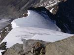
From there 3hrs to the top following two glaciers and stay alert of crevices. From the top very good take off posibilities S/SW to NO/O possible.
Beautiful view into Hohe Tauern, Dolomiten and Zillertaler Alpen.
Reisebericht bei den Reiseberichten "Dreiherrenspitze"
Bewertung der Fluggebiets- und der Seitenqualität
Flug
Very nice flight down the glacier and Ahrntal back to Kasern with nice midday and late summer thermal conditions (12.9.2006)
Schwierigkeit
alpine conditions
Besonderheiten und Webcam
| this tour is a bit remote but you are on your own and can fully enjoy it - the 360 view is simply spectacular - wait for the right weather even if it takes time |
Walk and Fly
Ausgangspunkt:
apart from glacier crevices there is one steeper part to climb with irons and axe.
Alpine experience required
Wegbeschreibung:
see charts
Sonstiges:
great tour
Wissenswertes
Unterkunft:
stay in Birnlückenhütte - very nice ambiance
Anfahrt:
well I wish I could have directly flown into Ahrntal
Download: Google Earth Dateien für Fluggebiet und Flugdaten (IGC, OLC)
Download: Google Earth Dateien (KML-Format), Flugdaten (IGC Format)
Die letzten 3 Flüge
Leider keine OLC Daten vorhanden.
Flugdaten von www.paraglidingforum.com
Leider keine OLC Daten von www.paraglidingforum.com vorhanden.
Alle Fluggebiete und Flugschulen in der Nähe anzeigen