South Mountain, 780 Meter
          
Talort:
Phoenix
Höhe Talort:
420 Meter
Höhenunterschied:
250
bis
355
Meter
Start Richtungen:
Seilbahn:
Nein
Streckenflug:
Nein
Soaring:
Keine Angabe
Windenschlepp:
Nein
Walk and Fly:
Nein
Ski and Fly:
Nein
Drachen:
Keine Angabe
UL:
Keine Angabe
Google Maps:
Qualität Fluggebiet:
Qualität dieser Seite:
Statistik:
Adoption (User):
-
Zuletzt bearbeitet:
26.04.2020
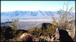
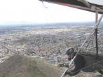
South Mountain is, according to statistics the largest city park of the world. The 13 mile long chain of hills south of Phoenix has been flown at since the eighties.
Bewertung der Fluggebiets- und der Seitenqualität
Flug
You require discipline for ridge soaring and thermal flying at South Mountain Park. There are also many hikers, mountian bikers and horse riders, seeking peace and quite here.
Schwierigkeit
The park can become very full especially on holidays and weekends. One must take care with the limited flight altitude and the antennas. You must complete the obligatory registration before flying, also USHGA and AHGA cards are mandatory on registration.
Besonderheiten und Webcam
Wissenswertes
Sonstiges:
Requirements: H3, H2 sponsored, P3, P2 sponsored. Show valid USHGA and AZHPA IDs upon request. Visiting pilots can obtain a visiting pilot pass at azhpa.org and show the registration/payment form as proof.
Detailed infoat azhpa.org/south-mountain/.
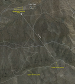
Startplätze
Startplatz:
South Mountain
GPS-Koordinaten:
Startrichtung:

S Schwierigkeit:
leicht
Höhe über NN:
795
SE to SSW; SSE is best. Summer evenings are usually too west to fly from the south launch.
Startplatz:
South Mountain
GPS-Koordinaten:
Startrichtung:

N NW Schwierigkeit:
mittel
Höhe über NN:
720
NW to NNE 0-20 mph. Can be launchable in the evenings when the south launch is indicating west winds
|
Landeplätze
Landeplatz:
LZ -South
GPS-Koordinaten:
Schwierigkeit:
mittel
Höhe über NN:
440
Straight in front of launch, just before the houses, visible from launch as a small, circular, bare patch. Has slight downhill slope to the south. Paraglider pilots should set up their approach so as to not overfly the wash to the west of the LZ and plan on landing short of the LZ to compensate for the famous South Mountain Pop. Much of the terrain around the LZ is usable for landing, just avoid getting popped and floating into or close to the houses
Landeplatz:
LZ -North
GPS-Koordinaten:
Schwierigkeit:
mittel
Höhe über NN:
470
Straight in front of launch is the Kart Track. Its got a large paved parking lot and a big open dirt area to the west, the LZ is the dirt area to the west, not the parking lot!
|
Download: Google Earth Dateien für Fluggebiet und Flugdaten (IGC, OLC)
Download: Google Earth Dateien (KML-Format), Flugdaten (IGC Format)
Die letzten 3 Flüge
Leider keine OLC Daten vorhanden.
Flugdaten von www.paraglidingforum.com
Leider keine OLC Daten von www.paraglidingforum.com vorhanden.
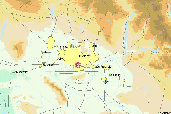
Umgebungskarte
  Fluggebiet  Flugschule  Aktuelle Position |
Fluggebiete in der Nähe (Radius: 50 km)
Nordamerika » USA » Arizona
Entfernung:
0 km
Höhenuntersch.:
220
Meter
Ort:
Shaw Butte
Streckenflug:
Ja
Startplatz:
leicht
Landeplatz:
Keine Angabe
Start Richtungen:
Shaw Butte is located near Phoenix, Shaw Butte lies in the vicinity of Phoenix, which makes it to a favorite spot for the flyers in Arizona. From here, one can also get well away from the city, the long distance record lies at 153 miles.
Flugschulen in der Nähe (Radius: 50 km)
Nordamerika » USA » Arizona
Arizona Hang Glider Association
Po Box 39013,
Phoenix, Az 85069 www.ahga.org
Entfernung: 0 km
Die AHGA war die zweite Vereinigung ihrer Art in den Staaten, daher auch der Name "Hang Glider" statt "Hang Gliding Association" - damals nannte...
Nordamerika » USA » Arizona
Die Website von Galen Shawn Jarrell ist vom Netz gegangen aber vielleicht ändert sich das wieder. Bevor ihr euch aber auf den Weg nach Phoenix...
Nordamerika » USA » Arizona
Bill Holmes ist der Chef der Sky Masters, deren Website erreicht man zur Zeit jedoch nicht.
Alle Fluggebiete und Flugschulen in der Nähe anzeigen
|