Großvenediger, 3666 Meter


Talort:
Hopffeldboden
Höhe Talort:
1000 Meter
Höhenunterschied:
2666
Meter
Start Richtungen:
Seilbahn:
Nein
Streckenflug:
Ja
Soaring:
Nein
Windenschlepp:
Nein
Walk and Fly:
Ja
Ski and Fly:
Ja
Drachen:
Nein
UL:
Nein
Qualität Fluggebiet:
Qualität dieser Seite:
Statistik:
Adoption (User):
Axel7 seit 05.09.2008
Zuletzt bearbeitet:
09.05.2011
7.5.2011
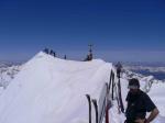
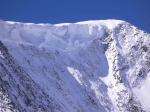
Und wieder ging es bei besten Bedingungen auf den Großvenediger. Diesmal direkt, dh per Taxi von Hopffeldboden (ist jetzt ein grosser Parkplatz mit Parkautomat! Oh tempora oh mores? (;-)))zur Materialseilbahn und von dort in guten 5 Stunden per Ski auf den Gipfel - Gletscherspalten noch sehr gut bedeckt - Rückflug bei sehr leichtem Südwind - Startpanorama aus meiner Sicht das beste in Österreich. Trotz bestem Wetter nur wenige Skitourengeher unterwegs - und eine Minderheit sogar mit Schneeschuhen oder Steigeisen. Taxi Postalm Tel- +43-6641116520.
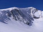
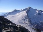
Leave the car at Hopfeldboden - take the cab to base of Material-lift just before the glacier and walk up to Kürsinger Hütte (2558m, on the winter path 27.5.2005) Next day ski back down to the glacier and walk up to the top - beware of crevices just before Kleinvenediger.
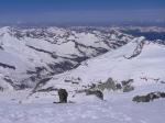
Brilliant view from the top with take off possibilities in virtually every direction - just due west would need some creativity
Reisebericht bei den Reiseberichten "Grossvenediger"
Bewertung der Fluggebiets- und der Seitenqualität
20.10.2008
[Axel7]
Annex
Für den Flug ist eine Flugerlaubnis des NP erforderlich - diese wurde eingeholt
mehr
19.10.2008
Nationalpark
Netter Reisebericht.
Aber eine Anmerkung: Im Nationalpark "Hohe Tauern" ist Drachen- und Gleitschirmfliegen nicht erlaubt.
mehr
|
|
Flug
Take off to the north over the glacier step towards Keeskogel and fly down the Untersulzbachtal. Thermal as long as needed then land on the gras at the parking place of Hopffeldboden.
You might need to answer questions to tourists about where the heck you come from with skis and paraglider at the beginning of summer landing with skis on gras in mai at 27degrees Celsius.
Absolutely top tour!
Schwierigkeit
Do not underestimate the fitness you need to reach the top. It is quite a distance but worth every meter.
Walk and Fly
Ausgangspunkt:
Hopffeldboden, Kürsinger Hütte, Grossvenediger and return flight
Wegbeschreibung:
see charts
Sonstiges:
The Untersulzbachtal is quite long so make sure you do not waste altitude and have an eye on out landing spots
The distance from summit to Hopffeldboden is some 16kms - so you get it all - a long distance flight inclusive.
There have been quite a few discussions in the past about the legal situation of flying in the National Park Hohe Tauern - some of which where quite emotional - the author has invested significant time to clarify it including discussions with lawyers familiar with austrian law - here is the summary:
To clarify the legal situation:
The NP Hohe Tauern and its legal situation is based on the three country laws of Tirol, Salzburg and Kärnten (see www.hohetauern.at)and apply in their correlating territory:
1.)According to the "Landesgesetzblatt Tirol dated October 1991 §6
part f) "die Verwendung von motorbetriebenen Luftfahrtzeugen ... zu sportlichen Zwecken... unterhalb 5000Metern ist verboten (kein Verbot für Gleitsegel), womit Paragleiten nicht verboten ist.
part b) "die Durchführung von Aussenlandungen und Aussenabflügen von Luftfahrzeugen ist verboten", wobei hier motorbetriebene gemeint sind. Trotzdem könnte man theoretisch auch Luftsportgeräte (Paragleiter) einbeziehen, weshalb man sich vor dem Flug erkundigen sollte ob der Start vom Gletscher zwecks verlassen des NP auf direktem Weg und Landung ausserhalb des NP gestattet wird
2.)The Salzburg law does not mention paragliders and only forbids the engine supported aircraft - therefore it is the most liberal for paragliding
Take off, flight and landing is not forbidden, provided no damage is done to nature (§5,Abs.2)
3.) The Kärnten law prohibits (§6,Abs 3, b, d) delta and paragliding activities
Regarding Tirol, Ost-Tirol and Salzburg where flying with paraglider is not forbidden you need to talk to the owner of the potential take off ground (overlying paragliding law of Austria) which is in the national park in the lower areas mostly farming ground and the farmer and in the higher altitude areas predominantely the "Alpenverein".
If the owner is ok with the take off you are fine.
So much to the formal parameters.
Of course with the entry of Austria into the european union - the european law applies as well - this is for somebody else to clarify the legal implications ;-))).
So only fly where legally possible.
Anmerkung: wer zurückfliegt benutzt natürlicherweise nicht das Taxi im Tal für den Rückweg - und damit ist es auch ein Beitrag zu mehr Umweltschutz, ganz im Sinne der Nationalparkziele
Download: Google Earth Dateien für Fluggebiet und Flugdaten (IGC, OLC)
Download: Google Earth Dateien (KML-Format), Flugdaten (IGC Format)
Die letzten 3 Flüge
Leider keine OLC Daten vorhanden.
Flugdaten von www.paraglidingforum.com
Leider keine OLC Daten von www.paraglidingforum.com vorhanden.
Alle Fluggebiete und Flugschulen in der Nähe anzeigen