Paragliding 365, das ist Paragliding, Drachen fliegen, Hängegleiten das ganze Jahr - Welt weit.
Home » Fluggebiete » Europa » Bosnien-Herzegowina

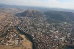
Planinica - Mostar, Bosnia and Hercegovina, 790 Meter

Seilbahn: Nein Streckenflug: Ja Soaring: Ja Windenschlepp: Ja Walk and Fly: Ja Ski and Fly: Nein Paraglider: Ja Drachen: Nein Webcam: Nein Keine GPS Daten vorhanden Keine IGC Daten vorhanden
Talort:
Mostar
Höhe Talort:
80 Meter
Höhenunterschied:
710 Meter
Start Richtungen:
Seilbahn:
Nein
Streckenflug:
Ja
Soaring:
Ja
Windenschlepp:
Ja
Walk and Fly:
Ja
Ski and Fly:
Nein
Drachen:
Nein
UL:
Nein
Qualität Fluggebiet:
Qualität dieser Seite:
Statistik:
Votes, 5469 Hits
Adoption (User):
paramara seit 22.10.2007
 
Zuletzt bearbeitet:
22.10.2007
22.10.2007
Paragliding Fluggebiet Europa » Bosnien-Herzegowina,Planinica - Mostar, Bosnia and Hercegovina,
9 Votes 1781 Hits
[paramara]
[Bild hinzufügen]
Main direction for flying SW and E flyable W,S, SE

Take off :
Two take off places.

1.
facing SW it's 800m ASL. It's a rocky place with a little grass. 3 gliders can start at the same time. Flying time afternoon ridge and thermals soaring.

2. facing E Take off time from 11:00 to 13:00 during first morning thermals


Landing :

2 landing fields, both of them are at the edge of town and both are reachable from both take off places.
1. 'Vihovici' is 160 ASL small 40x70m clean area for landing.

2. 'Sjeverni logor' 80 ASL is further down the wind but much bigger, must cross over river to get on this landing point and winds sometimes are stronger than on first landing place.

Both are suitable for beginners. Only Sjeverni logor is suitable for hang gliders.

It's possible even to do a top landing - very easy

Going there :

To the hill 20 min drive with car from center of town Mostar.

5 min walking from one take off to another

12 km from Mostar is situated a big field with road for winch tow in all directions.

For some photos Click Here

Bewertung der Fluggebiets- und der Seitenqualität

Qualität des Fluggebiets
Qualität dieser Seite
Ausführliche Bewertung Ausführlicher Kommentar

Flug

For more informations please ask
para.mara@yahoo.com

Walk and Fly

Ausgangspunkt:
1:30 - 2:00 hours of walking from center of town to take off.
Wegbeschreibung:
Sonstiges:
www.pgk-extreme.page.tl

Soaring

Soaringbedingungen:
ridge and thermals

Startplätze

Landeplätze

Download: Google Earth Dateien für Fluggebiet und Flugdaten (IGC, OLC)

Download: Google Earth Dateien (KML-Format), Flugdaten (IGC Format)
Die letzten 3 Flüge
Leider keine OLC Daten vorhanden.

Flugdaten von www.paraglidingforum.com
Leider keine OLC Daten von www.paraglidingforum.com vorhanden.

Alle Fluggebiete und Flugschulen in der Nähe anzeigen

Fluggebiete | Flugschulen | Tandem Paragliding | Szene News| Neuigkeiten  ]
Fluggebiet suchen | Flugschule suchen | Unterkunft suchen  ]
Reiseberichte | Reisespecials  ]
Datenschutz | Impressum | Kontakt | Sitemap  ]