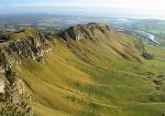
Te Mata Peak, 395 Meter
          
Talort:
Te Mata
Höhe Talort:
25 Meter
Höhenunterschied:
370
Meter
Start Richtungen:
Seilbahn:
Nein
Streckenflug:
Ja
Soaring:
Ja
Windenschlepp:
Nein
Walk and Fly:
Nein
Ski and Fly:
Nein
Drachen:
Ja
UL:
Nein
Google Maps:
Qualität Fluggebiet:
Qualität dieser Seite:
Statistik:
Adoption (User):
-
Zuletzt bearbeitet:
22.07.2020
Te Mata Peak 3km Soaring Ridge
A one off flying site. Paragliders and Hang Gliders come here at your costs. Beginners should start in at least 12 knots. The thermic guarantees high and far flights ! Landings is on a field near the Waimarama Road.
.
Bewertung der Fluggebiets- und der Seitenqualität
Besonderheiten und Webcam
| For all further information and special flight rules please contact beforehand Airplay Paragliding under enquiries@airplay.co.nz |
Wissenswertes
Anfahrt:
Hawkes is located direct on the coast along the National Couch Route. It can be reached by car in under a half day's drive from all cities in New Zealand, and is easily reached. It you have to opportunity check out the other sites in this region (8 to be exact), please however only with 4 wheel drive.
Sonstiges:
New Zealand's Hawkes Bay is renowned for its landscape, its wine and its mediterranen lifestyle.
Startplätze
Startplatz:
Te Mata Peak
GPS-Koordinaten:
Startrichtung:

N S W Schwierigkeit:
mittel
Höhe über NN:
395
Nur der Nord-SP ist klein und steil
Auffahrt via Teerstrasse, oben viel PP
.
|
Landeplätze
Landeplatz:
Tuki-Tuki River
GPS-Koordinaten:
Schwierigkeit:
leicht
Höhe über NN:
25
Hier unterhalb der Hauptstrasse = Waimarama Road
Entlang dem Fluss gibts viele freie Wiesenflächen.
.
|
Download: Google Earth Dateien für Fluggebiet und Flugdaten (IGC, OLC)
Download: Google Earth Dateien (KML-Format), Flugdaten (IGC Format)
Die letzten 3 Flüge
Leider keine OLC Daten vorhanden.
Flugdaten von www.paraglidingforum.com
Leider keine OLC Daten von www.paraglidingforum.com vorhanden.
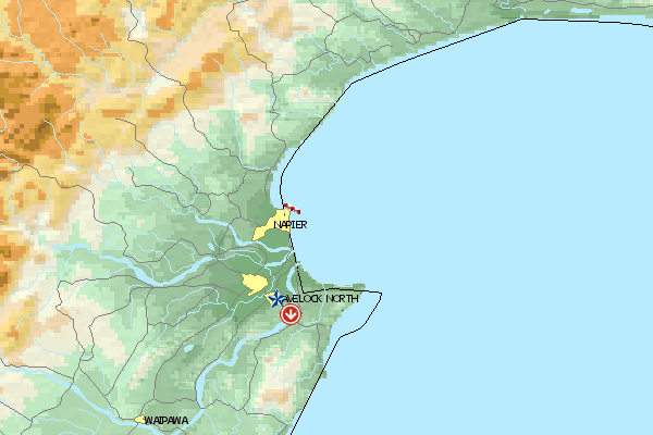
Umgebungskarte
  Fluggebiet  Flugschule  Aktuelle Position | Orte in der Nähe
Napier City (0 km)
Napier (0 km)
Onekawa (0 km)
Ahuriri (1 km)
Port Ahuriri (1 km)
Westshore (3 km)
Greenmeadows (7 km)
Mast (7 km)
Awatoto (8 km)
Meeanee (8 km)
Puk-kura (8 km)
Bay View (8 km)
Taradale Town District (8 km)
Taradale (8 km)
Petane (9 km)
|
Fluggebiete in der Nähe (Radius: 50 km)
Australien / Ozeanien » Neuseeland
Entfernung:
24 km
Höhenuntersch.:
24
Meter
Ort:
Napier
Streckenflug:
Ja
Startplatz:
leicht
Landeplatz:
leicht
Start Richtungen:
Beautiful beach flying site on Hawkes Bay with many possibilities for both the beginner and experienced pilot. Hang Gliders fly here however, considerably further than the Paraglider. The record lies until after Wairoa.
Australien / Ozeanien » Neuseeland
Entfernung:
24 km
Höhenuntersch.:
408
Meter
Ort:
Napier
Streckenflug:
Ja
Startplatz:
schwer
Landeplatz:
schwer
Start Richtungen:
This site is located on the southern end of the Kaokaoroa Range, directly north of Otane. It is possible for the Hang Glider to land above again.
Australien / Ozeanien » Neuseeland
Entfernung:
24 km
Höhenuntersch.:
61
Meter
Ort:
Napier
Streckenflug:
Ja
Startplatz:
mittel
Landeplatz:
mittel
Start Richtungen:
A crazy beach flying site with a high cliff. Caution with the power poles and the model airplanes, that are always racing around here. Please give yourself sufficent space and distance. Please do not land in the vicinity of the horses. You may not fly over Cape Kidnappers because of the...
Flugschulen in der Nähe (Radius: 50 km)
Australien / Ozeanien » Neuseeland
Airplay Paragliding School
Hawkes Bay
Havelock North www.airplay.co.nz
Entfernung: 5 km
4 Stunden von Wellington auf der nördlichen Insel von Neuseeland findet ihr in dem kleinen Ort Havelock North die Paragliding Schule "Airplay"....
Alle Fluggebiete und Flugschulen in der Nähe anzeigen
|