MOUNT CARGILL, 600 Meter
          
Talort:
Dunedin
Höhe Talort:
93 Meter
Höhenunterschied:
537
Meter
Start Richtungen:
Seilbahn:
Nein
Streckenflug:
Ja
Soaring:
Keine Angabe
Windenschlepp:
Nein
Walk and Fly:
Nein
Ski and Fly:
Nein
Drachen:
Keine Angabe
UL:
Keine Angabe
Google Maps:
Qualität Fluggebiet:
Qualität dieser Seite:
Statistik:
Adoption (User):
-
Zuletzt bearbeitet:
15.07.2016
If you can start, orientate very specifically into the wind. Over 10 knots, you can guarentee lovley flight conditions. Landing is approx. 3 km raway at the so-called silver shed. The start stipulates only a short start. Take caution with the fences when landing!
Bewertung der Fluggebiets- und der Seitenqualität
Besonderheiten und Webcam
| You can only fly at this site by arrangement with the pilots on the spot, so that they are able to assist you. Otherwise contact Sterling Meyer:sterling.meyer@stonebow.otago.ac.nz |
Wissenswertes
Anfahrt:
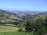
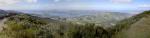
Dunedin is also named the "Edinburgh of the south". You will find this lovely Victorian city lain on the southern island New Zealand directly on Highway no. 1 south of Christchurch. From here take the Pine Hill Road , then turn into the Mount Cargill Road and follow it up to the peak of the mountain.
Sonstiges:
Die Fluggebiete bitte nur in Absprache mit den Piloten vor Ort fliegen, damit diese Euch einweisen können. Kontakt über Sterling Meyer:
sterling.meyer@stonebow.otago.ac.nz
Startplätze
Startplatz:
Mt.Cargill
GPS-Koordinaten:
Startrichtung:

N S Schwierigkeit:
Keine Angabe
Höhe über NN:
630
|
Landeplätze
Landeplatz:
Forester Park
Schwierigkeit:
mittel
Höhe über NN:
0
Landing is in the Forrester park on one of the three Football fields. Pay attention at the same time to the streets lights!
|
Download: Google Earth Dateien für Fluggebiet und Flugdaten (IGC, OLC)
Download: Google Earth Dateien (KML-Format), Flugdaten (IGC Format)
Die letzten 3 Flüge
Leider keine OLC Daten vorhanden.
Flugdaten von www.paraglidingforum.com
Leider keine OLC Daten von www.paraglidingforum.com vorhanden.
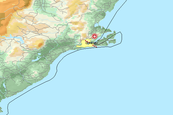
Umgebungskarte
  Fluggebiet  Flugschule  Aktuelle Position | Orte in der Nähe
Dunedin (0 km)
Taieri (0 km)
Roslyn (1 km)
Mornington (3 km)
Halfway Bush (3 km)
North East Valley (3 km)
Ravensbourne (4 km)
Caversham (4 km)
Flagstaff (4 km)
Stony Knowe (4 km)
Flagstaff Hill (5 km)
Flagstaff (5 km)
Whakaari (5 km)
Burnside (5 km)
Ocean Grove (5 km)
|
Fluggebiete in der Nähe (Radius: 50 km)
Australien / Ozeanien » Neuseeland
Entfernung:
7 km
Höhenuntersch.:
-43
Meter
Ort:
Dunedin
Streckenflug:
Ja
Startplatz:
leicht
Landeplatz:
leicht
Start Richtungen:
Fantastic flight zone, fantastic landscape, fantastic ambience! This site possesses all possibilities. Large areas for both the start and n the landing.
Australien / Ozeanien » Neuseeland
Entfernung:
7 km
Höhenuntersch.:
-63
Meter
Ort:
Dunedin
Streckenflug:
Ja
Startplatz:
leicht
Landeplatz:
leicht
Start Richtungen:
Hang Gliders will find outstanding thermal conditions for gliding here. Start and landing possibilities cover a large free area providing a comfortable flight.
Australien / Ozeanien » Neuseeland
Entfernung:
7 km
Höhenuntersch.:
7
Meter
Ort:
Dunedin
Streckenflug:
Ja
Startplatz:
leicht
Landeplatz:
leicht
Start Richtungen:
Only in easy wind (less than 8 knots), the hang glider should start here down the mountain. Landing is at the Forrester Park on the 3 Football fields, that you can see from the start.
Alle Fluggebiete und Flugschulen in der Nähe anzeigen
|