Sandymount Beach, 240 Meter
          
Talort:
Dunedin
Höhe Talort:
93 Meter
Höhenunterschied:
147
Meter
Start Richtungen:
Seilbahn:
Nein
Streckenflug:
Ja
Soaring:
Keine Angabe
Windenschlepp:
Nein
Walk and Fly:
Nein
Ski and Fly:
Nein
Drachen:
Keine Angabe
UL:
Keine Angabe
Google Maps:
Qualität Fluggebiet:
Qualität dieser Seite:
Statistik:
Adoption (User):
-
Zuletzt bearbeitet:
15.07.2016
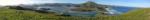
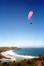
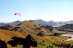
Very popular flight zone in the vicinity of Dunedin, at the coast.
People come here in swarms. Also the area is named the champagne-side of Dunedin. Lovely outlook, best start conditions and landing conditions. It can be landed also above again. If you land below, you must be sure on foot back to the starting point, because it there are no secured ways or streets. Straight in easy wind around the 6-8 knots the thermic conditions are a dream! You need only caution before the Macrocarpa trees.
Bewertung der Fluggebiets- und der Seitenqualität
Wissenswertes
Anfahrt:
Direkt an der Otago Peninsula Road gelegen. Folgt einfach der Ausschilderung nach Lovers Leap.
Sonstiges:
Die Fluggebiete hier bitte nur in Absprache mit den Piloten vor Ort fliegen, damit diese Euch einweisen können. Kontakt über Sterling Meyer:
sterling.meyer@stonebow.otago.ac.nz
You can only fly at this site by arrangement with the pilots on the spot, so that they are able to assist you. Otherwise contact Sterling Meyer:sterling.meyer@stonebow.otago.ac.nz
Startplätze
Startplatz:
SANDYMOUNT
Startrichtung:

NO Schwierigkeit:
schwer
Höhe über NN:
240
|
Landeplätze
Landeplatz:
SANDYMOUNT
Schwierigkeit:
schwer
Höhe über NN:
0
|
Download: Google Earth Dateien für Fluggebiet und Flugdaten (IGC, OLC)
Download: Google Earth Dateien (KML-Format), Flugdaten (IGC Format)
Die letzten 3 Flüge
Leider keine OLC Daten vorhanden.
Flugdaten von www.paraglidingforum.com
Leider keine OLC Daten von www.paraglidingforum.com vorhanden.
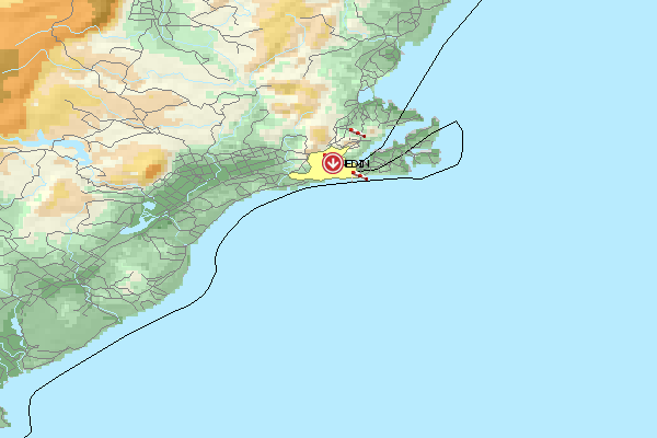
Umgebungskarte
  Fluggebiet  Flugschule  Aktuelle Position | Orte in der Nähe
Dunedin (0 km)
Taieri (0 km)
Roslyn (1 km)
Mornington (3 km)
Halfway Bush (3 km)
North East Valley (3 km)
Ravensbourne (4 km)
Caversham (4 km)
Flagstaff (4 km)
Stony Knowe (4 km)
Flagstaff Hill (5 km)
Flagstaff (5 km)
Whakaari (5 km)
Burnside (5 km)
Ocean Grove (5 km)
|
Fluggebiete in der Nähe (Radius: 50 km)
Australien / Ozeanien » Neuseeland
Entfernung:
0 km
Höhenuntersch.:
-43
Meter
Ort:
Dunedin
Streckenflug:
Ja
Startplatz:
leicht
Landeplatz:
leicht
Start Richtungen:
Fantastic flight zone, fantastic landscape, fantastic ambience! This site possesses all possibilities. Large areas for both the start and n the landing.
Australien / Ozeanien » Neuseeland
Entfernung:
0 km
Höhenuntersch.:
-63
Meter
Ort:
Dunedin
Streckenflug:
Ja
Startplatz:
leicht
Landeplatz:
leicht
Start Richtungen:
Hang Gliders will find outstanding thermal conditions for gliding here. Start and landing possibilities cover a large free area providing a comfortable flight.
Australien / Ozeanien » Neuseeland
Entfernung:
0 km
Höhenuntersch.:
7
Meter
Ort:
Dunedin
Streckenflug:
Ja
Startplatz:
leicht
Landeplatz:
leicht
Start Richtungen:
Only in easy wind (less than 8 knots), the hang glider should start here down the mountain. Landing is at the Forrester Park on the 3 Football fields, that you can see from the start.
Alle Fluggebiete und Flugschulen in der Nähe anzeigen
|