El Manaclar, 1800 Meter
|
|
| Talort: |
Bani, El Manaclar (Insel Hispanola Dom. Rep.), 50 Meter |
| Höhenunterschied: |
950
Meter |
| Streckenflug: |
Ja |
| Seilbahn: |
Nein |
| Windenschlepp: |
Nein |
| Walk and Fly: |
Nein |
|
El Manaclar liegt zwischen Azua und Matua nahe der Stadt Bani, ca. 1,5h von Santo Domingo.
Allradantrieb ist erforderlich.
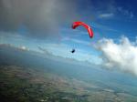
Dieser Gebirgszug ist ein Ausläufer des Zentralmassivs der bis auf 1800m ansteigt. Das Fluggebiet ist sehr anspruchsvoll! Es gibt keinen Landeplatz der im Gleitwinkel erreichbar ist, also seht unbedingt zu daß Ihr Höhe macht, wenn Ihr euch nicht in der Wildnis versenken wollt!!
Location:: The site is about 1 h 30 m SW of Santo Domingo, near a city called Bani. A four-wheel drive vehicle is required.
Launch Altitude AGL [m]:: 1000
Description:: The takeoff faces S. It is located in a branch of the main Central Range. This smaller range grows up to 1800 m heading NNW as it penetrates the main Central Range.
Conditions and flight:: This is an advanced flight. There is no landing field in your glide range from takeoff, so you've got to be sure you'll go up (most of the time is pretty obvious you will).
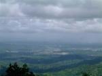
The predominating wind in the area and at that altitude is E, but the takeoff heads S. The range travels N and that's the main XC route. To the W side of the range there is a wide valley that runs parallel to it. On the other side, to the E, there is nothing but bigger mountains ending in the steepest valleys I've ever seen.
So the easiest XC flight is when the meteo wind is weak enough to let the anabatic flow set in at the takeoff height.
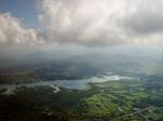
Maximum XC distance registered:: 33 km
|
|
|

|
Startplätze |
| Startplatz: |
Start |
| Startrichtung: |
S |
| Schwierigkeit: |
Keine Angabe
|
| Höhe über NN: |
1000 |
|
Der Startplatz liegt auf 1000m GND. Man startet in Richtung Süden.
|
|
|
|
|
|
|
Umgebungskarte
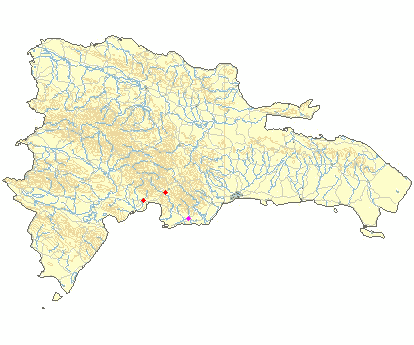
Interaktive Karte
|
Fluggebiete in der Nähe (Radius: 50 km) |
|
Nordamerika » Dominikanische Republic
La Manaclita, 1180 Meter

| Entfernung: | 33 km
|
|
Höhenuntersch.:
|
519
Meter
|
| Ort: | La Manaclita
|
| Streckenflug: | Ja
|
| Startplatz: |
mittel
|
| Landeplatz: |
mittel
|
Die optimale Thermik lädt praktisch zum langen soaren über die grüne Landschaft im inneren der Insel ein. Gerade am Nachmittag sind hier die...
|
|
|
Nordamerika » Dominikanische Republic
La Playita, 0 Meter
| Entfernung: | 46 km
|
|
Höhenuntersch.:
|
0
Meter
|
| Ort: | Azua
|
| Streckenflug: | Nein
|
| Startplatz: |
Keine Angabe
|
| Landeplatz: |
Keine Angabe
|
Location:: The takeoff is about 25 m S from Azua (1 h 45 m from Santo Domingo). A four-wheel drive vehicle is recommended.
Launch...
|
|
|
Nordamerika » Dominikanische Republic
Azua, 350 Meter
| Entfernung: | 46 km
|
|
Höhenuntersch.:
|
11
Meter
|
| Ort: | Provinz Azua
|
| Streckenflug: | Ja
|
| Startplatz: |
Keine Angabe
|
| Landeplatz: |
Keine Angabe
|
Insel Hispanola Dom. Rep./Haiti: Westlich entlang der Südküste ca. 1,5h von Santo Domingo entfernt liegt Azua. Für die Anfahrt braucht man einen...
|
|
|
|
|
|
|  |
|