Schneekarspitze, 3205 Meter


Talort:
Gerlos
Höhe Talort:
1100 Meter
Höhenunterschied:
2105
Meter
Start Richtungen:
Seilbahn:
Nein
Streckenflug:
Ja
Soaring:
Nein
Windenschlepp:
Nein
Walk and Fly:
Ja
Ski and Fly:
Ja
Drachen:
Nein
UL:
Nein
Qualität Fluggebiet:
Qualität dieser Seite:
Statistik:
Adoption (User):
Axel7 seit 05.09.2008
Zuletzt bearbeitet:
23.09.2008

|
22.09.2008
|
 |
|
0 Votes
|
1737 Hits
|
| [Axel7] |
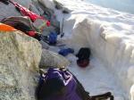
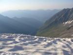
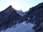
| Schneekarspitze north and south take off - very rare with perfect snow conditions |
|
[Bild hinzufügen]
Drive by car or mountainbike in to the Schönachtal from Gerlos until reaching the end of the valley Issanger 1471m. From there walk up the rest of the valley until you reach the glacier which you walk up straight to Schönachschneid 3000m (5hrs) - where I stayed for the night. Take off in the morning from Schönachschneid facing North. Alternative take off from Schneekarspitze across the ridge facing south.
Reisebericht bei den Reiseberichten "Keeskogel/Schneekarspitze"