Monte Rosa, 4554 Meter


Talort:
Alagna
Höhe Talort:
1062 Meter
Höhenunterschied:
3492
Meter
Start Richtungen:
Seilbahn:
Ja
Streckenflug:
Ja
Soaring:
Nein
Windenschlepp:
Nein
Walk and Fly:
Nein
Ski and Fly:
Ja
Drachen:
Nein
UL:
Nein
Qualität Fluggebiet:
Qualität dieser Seite:
Statistik:
Adoption (User):
Axel7 seit 02.09.2008
Zuletzt bearbeitet:
23.09.2008

|
22.09.2008
|
 |
|
4 Votes
|
1728 Hits
|
| [Axel7] |
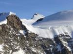
| view from piramide vincent towards punta gnifetti in the Monte Rosa chain - what a take off cliff!!! |
|
[Bild hinzufügen]
Walk&Fly from Alagna (1151) to Piramide Vincent (4215) and Pta Gnifetti (4554).
Take the lift to Pso dei Salati, then 2-3hrs walk to Rif Gnifetti.
From the Ref 2 hours to Vincent and 5 hrs to Gnifetti.
Vincent take off from S-W-N possible.
Gnifetti take off from SW to N possible.
Bewertung der Fluggebiets- und der Seitenqualität
Flug
Landing in Alagna, near the road at the entrance of the village
Schwierigkeit
high altitude take off and flight
alpine experience neccessary
Walk and Fly
Ausgangspunkt:
Wegbeschreibung:
Walk&Fly from Alagna (1151) to Piramide Vincent (4215) and Pta Gnifetti (4554).
Take the lift to Pso dei Salati, then 2-3hrs walk to Rif Gnifetti.
From the Ref 2 hours to Vincent and 5 hrs to Gnifetti.
Vincent take off from S-W-N possible.
Gnifetti take off from SW to N possible.
Sonstiges:
Download: Google Earth Dateien für Fluggebiet und Flugdaten (IGC, OLC)
Download: Google Earth Dateien (KML-Format), Flugdaten (IGC Format)
Die letzten 3 Flüge
Leider keine OLC Daten vorhanden.
Flugdaten von www.paraglidingforum.com
Leider keine OLC Daten von www.paraglidingforum.com vorhanden.
Alle Fluggebiete und Flugschulen in der Nähe anzeigen