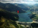
Las Aguitas, 900 Meter


Talort:
Las Aguitas
Höhe Talort:
188 Meter
Höhenunterschied:
712
Meter
Start Richtungen:
Seilbahn:
Nein
Streckenflug:
Ja
Soaring:
Keine Angabe
Windenschlepp:
Nein
Walk and Fly:
Keine Angabe
Ski and Fly:
Nein
Drachen:
Keine Angabe
UL:
Keine Angabe
Google Maps:
Qualität Fluggebiet:
Qualität dieser Seite:
Statistik:
Adoption (User):
-
Zuletzt bearbeitet:
23.07.2016
Hier stört keine Seebrise, denn das Gebiet liegt gut geschützt. Es kann hier bis zu 70 km weit über die herrliche Landschaft hinweg gehen.
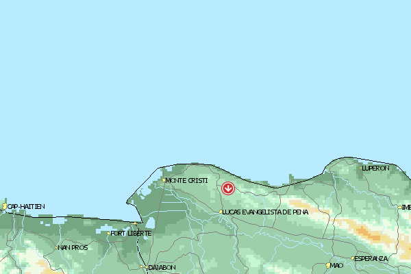
Location:: Las Aguitas is a 3 h 30 m drive from Santo Domingo heading WNW, in the Valle de San Juan. No four-wheel drive vehicle needed as you have a 30 m hike anyway. Gliders can be taken to the launch area on horses.
Launch Altitude AGL [m]:: 400
Description:: The takeoff is in the SW face of the Central Range, about 4 km from a town called Sabaneta. The Valle de San Juan at this level is about 500 m ASL, so the takeoff is over 900 m ASL. This part of the Central Range has very little erosion and mountains are sharp and over 2000 m high. The valley is over 20 km wide and the landscape is greener than the rest of the south because of the numerous rivers and water streams coming down form the Central Range.
Conditions and flight:: This site is also very protected form the Alisios wind and is definitely out of the reach of the moist sea breeze.
Thermals are wide with lovely cores (+5 over the peaks and +2 in the valley).
There are amazing XC possibilities. The Central Range runs WNW entering Haiti. This flight would be the continuation of the XC started in Azua (look at the map). If we ever get to join them, then we would have a 130 km flight in a Caribbean island... Should I say anything else?
Oh yes, just one more thing... there are great triangle possibilities too because wind blows mildly from E and there is a lot of activity over the valley. Plus, cloudbase is often above 3000 m !
Maximum XC distance registered:: 56 km Open Distance, 69 km Out and Back.


 Fluggebiet
 Flugschule
 Aktuelle Position