Mount Emu, 1342 Meter
          
Talort:
Tawonga
Höhe Talort:
360 Meter
Höhenunterschied:
940
Meter
Start Richtungen:
Seilbahn:
Nein
Streckenflug:
Ja
Soaring:
Ja
Windenschlepp:
Nein
Walk and Fly:
Nein
Ski and Fly:
Nein
Drachen:
Ja
UL:
Nein
Google Maps:
Qualität Fluggebiet:
Qualität dieser Seite:
Statistik:
Adoption (User):
-
Zuletzt bearbeitet:
10.08.2017
is a high and large mountain in the middle of the Kiewa Valley, with a view over Tawonga. In the NNE direction offers the possibility of a round flight over the Valley (40km), that leads you again back to the starting point. All other flight directions are mostly no longer than 5km long.
Bewertung der Fluggebiets- und der Seitenqualität
Schwierigkeit
Start from the local pub ! Approx. 15km out of Tawonga and 19km of Mitta, go to the left along the Eskdale Ridge Track. Follow it along for 4 km follows then you will come to a left bend. As an orientation, folow the powerlines fot the next 3 km. From the pub to the starting site only takes 30-40 minutes. Possible with 2-wheel drive !
Besonderheiten und Webcam
The starting place is difficult to find, please contact NEVHGC (the North East Vic Hang Gliding club) for details.
NEVHGC - VHPA
siteguide.org.au/Sites/Tawonga%20Gap.html
Phil Schroeder 0407 042 634 (Local HG-Pilot)
. |
Wissenswertes
Anfahrt:
You will find this site alongside at Tawonga-Valley, near Mount Beauty in north eastern Victoria. 230km NE of Melbourne.
Startplätze
Startplatz:
Mount Emu
Startrichtung:
Schwierigkeit:
mittel
Höhe über NN:
1300
|
Landeplätze
Landeplatz:
Iars Paddock
GPS-Koordinaten:
Schwierigkeit:
mittel
Höhe über NN:
360
siehe in : siteguide.org.au/Sites/Tawonga%20Gap.html
|
Download: Google Earth Dateien für Fluggebiet und Flugdaten (IGC, OLC)
Download: Google Earth Dateien (KML-Format), Flugdaten (IGC Format)
Die letzten 3 Flüge
Leider keine OLC Daten vorhanden.
Flugdaten von www.paraglidingforum.com
Leider keine OLC Daten von www.paraglidingforum.com vorhanden.
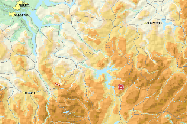
Umgebungskarte
  Fluggebiet  Flugschule  Aktuelle Position | Orte in der Nähe
Tawonga (0 km)
Mongans Bridge (4 km)
Tawanga, Mount (10 km)
Tawonga, Mount (10 km)
Kancoona (12 km)
Mount Beauty (14 km)
Running Creek (16 km)
Upper Gundowring (17 km)
Porepunkah (18 km)
Bright (18 km)
Freeburgh (18 km)
Dederang (18 km)
Wandiligong (20 km)
Eurobin (21 km)
Happy Valley (21 km)
|
Fluggebiete in der Nähe (Radius: 50 km)
Australien / Ozeanien » Australien » Victoria
Entfernung:
43 km
Höhenuntersch.:
970
Meter
Ort:
Mount Beauty
Streckenflug:
Ja
Startplatz:
leicht
Landeplatz:
leicht
Start Richtungen:
SP Eskdale Hill
Breite Waldschneise mit Teppich. Auffahrt via Forststrasse, der heisst Eskdale Spur Track.
In Mount Beauty gibt es ein Regional-Flugplatz mit UL-Schlepp und einer CTR ---> Infos holen.
.
Alle Fluggebiete und Flugschulen in der Nähe anzeigen
|