Horse Canyon, 1400 Meter
|
|
| Talort: |
Horse Canyon, 161 Meter |
| Höhenunterschied: |
1239
Meter |
| Streckenflug: |
Ja |
| Seilbahn: |
Nein |
| Windenschlepp: |
Nein |
| Walk and Fly: |
Nein |
| GPS Tal: |
32° 46' 11'' N,116° 29' 27'' W |
| GPS Berg: |
32° 46' 30'' N,116° 28' 35'' W |
|
The site is located in the desert an hour east of San Diego. Not surprisingly it proviedes outstanding thermic conditions and "Glass off's" in the afternoon.
Official Site Guide: https://www.sdhgpa.com/horse.html
|
|
Flug
The strong thermic conditions demand a certain ability and in the at afternoon-heat, Horse Canyon is usually suited only for Hang gliders. In the morning, flight pleasure is guaranteed with the 'glass off'. Best conditions you will find between S-SW winds, in the summer the winds unfortunately often change unfavorably to the north west.
Wissenswertes
| Anfahrt: |
Follow Interstate 8 out of San Diego; get of at Buckman Springs exit. You'll see the LZ at the exit.
For access to launch study Google Earth...
See Site Guide: https://www.sdhgpa.com/horse.html |
|

 
|
|
 |
|
3 Votes
|
914 Hits
|
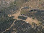
| [juevondue] |
| Horse LZ aus Richtung Startplatz - Juni 2004
(Jurgen von Dueszeln) |
|
|
Startplätze |
| Startplatz: |
Main Launch |
| GPS-Koordinaten: |
32° 46' 30'' N,116° 28' 35'' W |
| Startrichtung: |
|
| Schwierigkeit: |
mittel
|
| Höhe über NN: |
0 |
|
Begrenzter Platz und viele Steine erschweren den Start. Zudem gibtes manchmal eine richtige Schlange an Fliegern. Nach dem Start südlich halten, im Norden drohen Turbulenzen.
|
|
|
|
|
|
Landeplätze |
| Landeplatz: |
Landing Zone |
| Schwierigkeit: |
mittel
|
| Höhe über NN: |
0 |
|
Die Landezone ist groß und gut zu sehen, doch trotzdem landen viele auch erfahrene Piloten in den Büschen. Lifts und Sinks machen das Landen schwierig, am Besten mit viel Höhe ankommen und runterkreisen. Die Sandstraße und das Feld auf der anderen Seite der Interstate 8 sind potentielle Alternativen.
|
|
|
|
|
|
Umgebungskarte
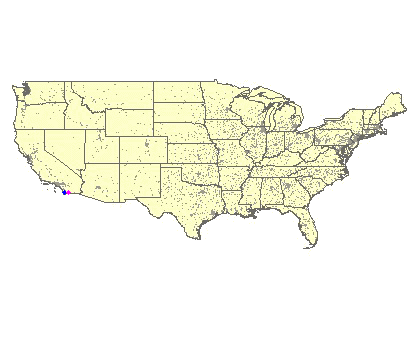
Interaktive Karte
| Orte in der Nähe
Bandini (29 km)
Tijuana (29 km)
Tia Juana (29 km)
Tijuana (29 km)
Zaragoza (29 km)
Colonia Buena Vista (31 km)
Colonia Libertad (31 km)
Colonia Veinte de Noviembre (31 km)
Agua Caliente (31 km)
Aguaje (31 km)
Colonia Herrera (32 km)
Concepción (32 km)
Rancho San Isidro Ajolojol (33 km)
Jesus Maria, Cerro (34 km)
La Meza (35 km)
|
|
|
Flugschulen in der Nähe (Radius: 50 km) |
|
Nordamerika » USA » Kalifornien
Hang Gliding Center of San Diego
Hang Gliding Center of San Diego
4328 Elma Ln
La Mesa, California 91941
Entfernung: 49 km
John Ryan leitet die Schule in San Diego. Mit dem Internet kennt er sich leider nicht so gut aus, wie mit der Fliegerei.
|
|
|
|
|
|  |
|