Florencia, 400 Meter
|
|
| Talort: |
Loma El Cubano, 100 Meter |
| Höhenunterschied: |
200
bis
300
Meter |
| Streckenflug: |
Nein |
| Seilbahn: |
Nein |
| Windenschlepp: |
Nein |
| Walk and Fly: |
Ja |
| GPS Berg: |
22° 09' 41.7'' N,78° 57' 54.4'' W |
|
|
Always contact the local pilots before taking off, there are strict regulations on the Cuban airspace, violation of those rules may create a problem not only for you but also for the locals.
|
|
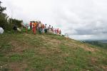
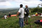
Walk and Fly
| Ausgangspunkt: |
There are at least two ways to hike up to the takeoff: starting from the town of Piedra or the better starting from the town of Florencia. The starting point at florencia is close to the house of Gilber (local pilot) |
| Wegbeschreibung: |
|
| Sonstiges: |
|
Wissenswertes
| Seilbahn: |
Sometimes is possible to rent horses from the farmers. |
| Fliegertreff: |
Ask in the town for "Casa de Gilber" +53 (33) 559146 |
|

|