Planinica Mostar, 780 Meter
|
|
| Talort: |
Mostar, 122 Meter |
| Höhenunterschied: |
658
Meter |
| Streckenflug: |
Nein |
| Seilbahn: |
Nein |
| Windenschlepp: |
Nein |
| Walk and Fly: |
Ja |
| GPS Tal: |
43° 21' 24.84'' N,17° 47' 22.56'' O |
| GPS Berg: |
43° 22' 33.60'' N,17° 46' 20.28'' O |
|
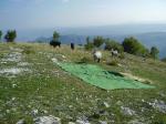
Take off : Two take off places.
1.
facing SW it's 800m ASL. It's a rocky place with a little grass. 3 gliders can start at the same time. Flying time afternoon ridge and thermals soaring.
2. facing E Take off time from 11:00 to 13:00 during first morning thermals
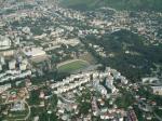
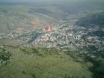
Landing : 2 landing fields, both of them are at the edge of town and both are reachable from both take off places.
1. 'Vihovici' is 160 ASL small 40x70m clean area for landing.
2. 'Sjeverni logor' 80 ASL is further down the wind but much bigger, must cross over river to get on this landing point and winds sometimes are stronger than on first landing place.
Both are suitable for beginners. Only Sjeverni logor is suitable for hang gliders.
It's possible even to do a top landing - very easy
Going there : To the hill 20 min drive with car from center of town Mostar.
5 min walking from one take off to another
|
|
Besonderheiten und Webcam
A lot of touristic attractions in this area.
Old town with Old Bridge (UNESCO)
Rafting on Neretva river, hiking Prenj and Cvrsnica mountains. Sea coast only 80 km away.
Medjugorje is known by religious tourism.... |
Walk and Fly
| Ausgangspunkt: |
|
| Wegbeschreibung: |
|
| Sonstiges: |
|
Wissenswertes
| Sonstiges: |
[URL]http://pgk-extreme.page.tl [/URL] |
|

Mehr Bilder ansehen
|