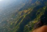
Skyline, 430 Meter
|
|
| Talort: |
Kingston, Jamaica, 200 Meter |
| Höhenunterschied: |
210
bis
280
Meter |
| Streckenflug: |
Ja |
| Seilbahn: |
Nein |
| Windenschlepp: |
Nein |
| Walk and Fly: |
Nein |
| GPS Tal: |
18° 1' 15'' N,76° 44' 33'' W |
| GPS Berg: |
18° 1' 48.8'' N,76° 44' 26'' W |
|
Launch site NE of Kingston - overlooking the Jamaican capital; beautiful residential garden environment mixed with marginal areas; flyable 365 days in warm tropical air; drive-up to launch by car in 20 min from town;
more details: paraglidingjamaica.com
OLC: xc.dhv.de/xc/modules/leonardo/index.php?name=leonardo&country=JM
|
|
Flug
Soaring in lee side thermals between 10 a.m. and 5 p.m.; good thermals (+5m/s) during dry season around midday; cloudbase normally at 1,000 - 1,500 m asl; XC potential; site record: 25 km (check our website for details: [URL]paraglidingjamaica.com[/URL]);
on poor days you can still do a 5-10 min 'sled ride' down to landing zone on sporting fields (200 m asl).
Schwierigkeit
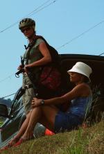
NOT a beginners site (intermediate level); good landing skills required as LZ is tight
Besonderheiten und Webcam
| The local pilots created the launch site in 2001 and feel responsible for its maintenance. We ask visitors to check with us before flying. We are happy to introduce you to the site and don't even charge a fee. |
Wissenswertes
| Seilbahn: |
No |
| Fliegertreff: |
No |
| Unterkunft: |
We can help you to find accomodation! |
| Anfahrt: |
Best with own car, but we can organise shuttle and retrieval on weekends. Call Jurgen before you go up to the launch: +1.876.366.5265 |
| Sonstiges: |
Warm temperatures (25 - 33 degrees C) allow to fly all year round in T-shirt and shorts; however, we recommend long sleeves for sun & scratch protection! |
|

Mehr Bilder ansehen
|