Azua, 350 Meter
|
|
| Talort: |
Provinz Azua, 79 Meter |
| Höhenunterschied: |
11
Meter |
| Streckenflug: |
Ja |
| Seilbahn: |
Nein |
| Windenschlepp: |
Nein |
| Walk and Fly: |
Nein |
|
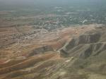
Insel Hispanola Dom. Rep./Haiti: Westlich entlang der Südküste ca. 1,5h von Santo Domingo entfernt liegt Azua. Für die Anfahrt braucht man einen Allrad-tauglichen Geländewagen. Hier gibt es inmitten der kleinen Hügelkette deren höchster Punkt bei etwa 350m liegt einen Startplatz auf 90m Höhe. Man kann von hier über die Halbwüste auf die 5km entfernte Küste im Süden schauen.
Location:: Azua is a town located about 1 h 20 m W from Santo Domingo, in the South Coast. A four-wheel drive vehicle is required, otherwise you have a 15 minutes hike up (not that hard).
Launch Altitude AGL [m]:: 90
Description:: The takeoff is located in a small range which highest point is less than 350 m AGL. This range runs E, parallel to the first big ranges of the Central Range which is about 2 km N. The takeoff faces the sea (Bahía de Ocoa), about 5 km S. Azua, as most of the rest of the South West, a semi-desert terrain.
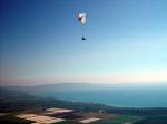
Conditions and flight:: It's an amazing flying site considering the takeoff altitude.
Pilots often takeoff early in the morning, about 10, to soar with the incoming sea breeze. A little later you can start feeling thermal activity that gets to a peak about 12:30 PM.
Thermals may be disordered, but if you are patient and get more than 800 m AGL then you can head N for the bigger stuff. If you succeed in reaching the big mountains behind the takeoff area, then the normal route would be NW along the Central Range, exploiting the altitude wind blowing E. XC potential is remarkable as the Central Range goes depp into Haiti, for more than a 150 km.
Maximum XC distance registered:: 60 km
|
|
Flug
Es ist erstaunlich wie gut sich hier trotz der geringen Starthöhe fliegen läßt. Normalerweise kann man hier morgens gegen 10h mit soaring beginnen, um kurz darauf in die sich gut entwickelnde Thermik einzusteigen, die gegen halb eins Ihren Höhepunkt erreicht.
Schafft man mehr als 800m GND zu machen, kann man nach Norden in Richtung der Berge drehen. Schafft man die zu erreichen, fliegt man NW zum Zentralmassiv um die Höhe und den Ostwind auszunutzen. Das Strecknflugpotenzial ist enorm, denn das Zentralmassiv reicht sogar über 150km bis nach Haiti hinein.
|

|
Startplätze |
| Startplatz: |
Startplatz |
| Startrichtung: |
|
| Schwierigkeit: |
Keine Angabe
|
| Höhe über NN: |
90 |
|
|
|
|
|
|
|
|
Umgebungskarte
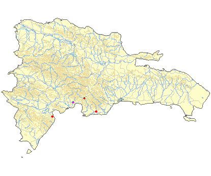
Interaktive Karte
|
Fluggebiete in der Nähe (Radius: 50 km) |
|
Nordamerika » Dominikanische Republic
La Playita, 0 Meter

| Entfernung: | 0 km
|
|
Höhenuntersch.:
|
0
Meter
|
| Ort: | Azua
|
| Streckenflug: | Nein
|
| Startplatz: |
Keine Angabe
|
| Landeplatz: |
Keine Angabe
|
Location:: The takeoff is about 25 m S from Azua (1 h 45 m from Santo Domingo). A four-wheel drive vehicle is recommended.
Launch...
|
|
|
Nordamerika » Dominikanische Republic
La Playita, 450 Meter
| Entfernung: | 0 km
|
|
Höhenuntersch.:
|
108
Meter
|
| Ort: | La Playita, Insel Hispanola Dom. Rep.
|
| Streckenflug: | Nein
|
| Startplatz: |
Keine Angabe
|
| Landeplatz: |
Keine Angabe
|
Fährt man von Santo Domingo aus knapp 2h die Südküste runter, erreicht man La Playita.
Ein geländetüchtiger Wagen (allrad) ist...
|
|
|
Nordamerika » Dominikanische Republic
La Manaclita, 1180 Meter
| Entfernung: | 22 km
|
|
Höhenuntersch.:
|
519
Meter
|
| Ort: | La Manaclita
|
| Streckenflug: | Ja
|
| Startplatz: |
mittel
|
| Landeplatz: |
mittel
|
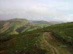
Die optimale Thermik lädt praktisch zum langen soaren über die grüne Landschaft im inneren der Insel ein. Gerade am Nachmittag sind hier die...
|
|
|
|
|
|
|  |
|