Matua, 900 Meter
|
|
| Talort: |
Dom. Republik, Insel Hispanola, 0 Meter |
| Höhenunterschied: |
250
Meter |
| Streckenflug: |
Nein |
| Seilbahn: |
Nein |
| Windenschlepp: |
Nein |
| Walk and Fly: |
Nein |
|
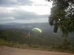
Matua liegt im Nordwesten von Santo Domingo. Anfahrt mit dem Auto. Startplatz auf 250m
Es handelt sich um Privatbesitz - die Eigentümer gestatten den Piloten freundlicherweise die Nutzung des Geländes zum Fliegen.
Der Startplatz ist auf der Spitze des Hügels und bildet einer Anfang einer sich auf ca. 45km nordwestlich erstreckenden Hügelkette, deren höchster Berg 900m über Grund hat.
Location:: Matúa is about 35 minutes NNW from Santo Domingo. Any vehicle can reach the launch area.
Launch Altitude AGL [m]:: 250
Description:: Matúa is a private property. The owners have gently allowed pilots to use it, even though it is their own weekend house. In fact, its front yard serves as the launching spot indeed. The takeoff is located in the top of the hill, just in the beginning of a range which runs heading NW for about 45 km, with a maximum height of 900 m ASL.
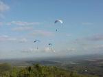
Conditions and flight:: Normally, gliders use the lift produced by the sea breeze coming from SE to soar gently in the afternoons. The chances to do thermal flying are not too high because the slope isn't steep enough.
If there is no sea breeze, the wind would normally blow E. There is an alternate takeoff for these days. There are more chances to fly thermals on this side because the slope is really abrupt, but you may find it a little turbulent.
Matúa is one of the most used training hills because it is the nearest to Santo Domingo.
Maximum XC distance registered:: 36 km (done only once!)
|
|
Flug
Normalerweise startet man mit dem Seewind aus SO und kann nachmittags hier soaren. Thermisches Fliegen ist an diesem Hang eher selten. Ohne Seewind bläst der Wind aus Ost und man verlegt den Startplatz zu einer etwas steileren Stelle. Hier sind die Chancen in der Thermik zu fliegen schon besser, aber etwas ruppig!
|

|
Startplätze |
| Startplatz: |
Startplatz |
| Startrichtung: |
|
| Schwierigkeit: |
Keine Angabe
|
| Höhe über NN: |
250 |
|
|
|
|
|
|
|
|
Umgebungskarte
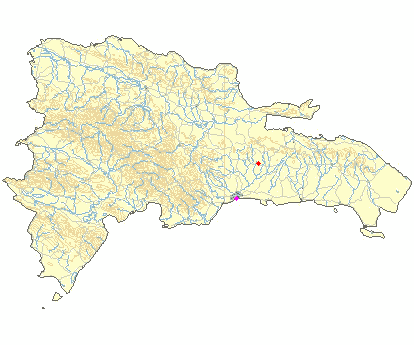
Interaktive Karte
|
Fluggebiete in der Nähe (Radius: 50 km) |
|
Nordamerika » Dominikanische Republic
Cotuí, 40 Meter

| Entfernung: | 0 km
|
|
Höhenuntersch.:
|
40
Meter
|
| Ort: | Santo Domingo
|
| Streckenflug: | Ja
|
| Startplatz: |
leicht
|
| Landeplatz: |
leicht
|
Entspannte und charmante Flugseite an der Küste der Dominikanischen Republik.
|
|
|
Europa » Spanien » Andalusien
Cerro Gordo, 70 Meter
| Entfernung: | 41 km
|
|
Höhenuntersch.:
|
70
Meter
|
| Ort: | Cañuelo
|
| Streckenflug: | Nein
|
| Startplatz: |
leicht
|
| Landeplatz: |
Keine Angabe
|
Wenn das Gebiet eines nicht ist, dann überlaufen. In einem Naturpark gelegen erlebt Ihr pures Vergnügen in freier Wildbahn - wunderschön. Doch...
|
|
|
|
|
|
|  |
|