Dinosaur (Blue Mountain), 2400 Meter
|
|
| Talort: |
Dinosaur (CO)/ Vernal (UT), 1800 Meter |
| Höhenunterschied: |
15
bis
660
Meter |
| Streckenflug: |
Ja |
| Seilbahn: |
Nein |
| Windenschlepp: |
Nein |
| Walk and Fly: |
Nein |
| GPS Tal: |
40° 14' 37'' N,109° 0' 50'' W |
|
One of the best XC-zones in Colorado, that is flown above all by Hang Gliders. Numerous competitions have already been competed in Dinosaur, the winner had 100miles goal.
Dinosaur (the village) lies in Colorado; the actual launch actually is just inside Utah.
|
|
Flug
Wind/ thermals during the day can be VERY rough (especially for PG)!
Ceiling often higher than 18000ft.
Schwierigkeit
Extreme long turnaround time: LZ-TO: 30miles/45mins; Vernal to launch: 65miles/ 1.5hrs! Not easy to find, seek out local advice.
It is recommend to land near the streets as the distances are easily deceiving and the walk-outs long. Oxygen is highly recommended for XC-flights.
For 'easy' XC follow I-40 East (as far as Steamboat Springs); do NOT land north of the Yampa River (very difficult retrieve).
Wissenswertes
| Unterkunft: |
Dinosaur (CO): hardly any decent options!
> much better Vernal (UT): 40mins to the West on US40. |
| Anfahrt: |
2 options:
a) EAST of Dinosaur follow paved (Harpers Corner) road (sign: Dinosaur Nat Mon). 0,5mi after passing sign 'Utah stateline' turn left into CR 1550 (Blue Mtn road), then left into CR 1565 (Hanggliding rd)
b) coming from Vernal on I-40, turn left at mile 169.7 (sign: Blue Mountain), then turn into CR 1550. You will pass Corral and Snake Pit LZ; when reaching the paved (Harpers Corner) road, turn left - then as above
From TO to LZ: leave paved road at sign 'Moffat CR 16' (right turn). |
| Sonstiges: |
Absolutely worth visiting (when the site is blown out): [b]Dinosaur National Monument[/b]: [url]www.nps.gov/dino/index.htm[/url]
>> continue on the paved road towards Harpers Corner; at 40°28'36.4"N/ 109°05'52.5"W turn right and leave the paved road (Echo Park rd). drive east: later on 2 options: turn left and drive to Echo Park or continue east on the Yampa River Bench road. Both are worth it! |
|

Mehr Bilder ansehen
|
Startplätze |
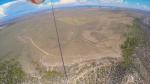
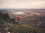
| Startplatz: |
Launch |
| GPS-Koordinaten: |
40° 22' 14.2'' N,109° 05' 24'' W |
| Startrichtung: |
SW, S |
| Schwierigkeit: |
mittel
|
| Höhe über NN: |
2480 |
|
|
|
|
|
|
|
Landeplätze |
| Landeplatz: |
Snake Pit |
| GPS-Koordinaten: |
40° 20' 41.2'' N,109° 06' 02.7'' W |
| Schwierigkeit: |
mittel
|
| Höhe über NN: |
1820 |
|
Der Hauptlandeplatz – eine Meile weiter findet ihr die Corral Landing Zone. HG's bevorzugen die Corral LZ.
|
|
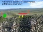
| Landeplatz: |
TOP |
| GPS-Koordinaten: |
40° 22' 15.1'' N,109° 05' 28.9'' W |
| Schwierigkeit: |
schwer
|
| Höhe über NN: |
2465 |
|
NICHT auf dem grossen Feld hinter dem Start landen (> Rotor!). Wenn überhaupt Top-gelandet werden muss, dann auf der West-Seite dieses Feldes. Hier ist das Gelände leicht abgerundet...
|
|
| Landeplatz: |
Corral LZ |
| GPS-Koordinaten: |
40° 20' 03.6'' N,109° 06' 34.0'' W |
| Schwierigkeit: |
mittel
|
| Höhe über NN: |
1840 |
|
etwas weiter als Snake Pit, aber offener und etwas besser angeströmt.
|
|
|
|
|
|
Umgebungskarte
Interaktive Karte
|
|
|  |
|