Mount Mittamatite, 990 Meter
|
|
| Talort: |
Corryong, 310 Meter |
| Höhenunterschied: |
680
Meter |
| Streckenflug: |
Ja |
| Seilbahn: |
Nein |
| Windenschlepp: |
Nein |
| Walk and Fly: |
Ja |
|
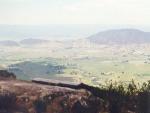
Mount Mitta Mitta
A high rocky mountain with good thermal ratios just over the Corryong Valley.
.
|
|
Flug
From the starting point fly directly left, to come into contact with the best thermals.
Walk and Fly
| Ausgangspunkt: |
|
| Wegbeschreibung: |
|
| Sonstiges: |
|
Wissenswertes
| Anfahrt: |
Near Corryong, 320km north east of Melbourne. Or 130km east of Albury (in NE Victoria). Go then to the Mount Mittamatite and start from the rocky underground.
. |
|


|
|
 |
|
0 Votes
|
959 Hits
|
| Mount Mittamatite |
| www.vhpa.org.au |
|
|
Startplätze |
| Startplatz: |
Mount Mitta Mitta |
| GPS-Koordinaten: |
36° 9' 5'' S,147° 51' 42.3'' O |
| Startrichtung: |
E |
| Schwierigkeit: |
mittel
|
| Höhe über NN: |
990 |
Scheint dass dieser SP zugewuchert ist.
.
|
|
|
|
|
|
Landeplätze |
| Landeplatz: |
Corryong - Mildren Street |
| GPS-Koordinaten: |
36° 11' 24.3'' S,147° 54' 38.7'' O |
| Schwierigkeit: |
mittel
|
| Höhe über NN: |
310 |
Grosse flache Wildwiese hinter dem Hotel 😎
bei Wettbewerben ist der Flugplatz als LP geöffnet.
.
|
|
|
|
|
|
Umgebungskarte
Interaktive Karte
| Orte in der Nähe
Corryong (0 km)
Thougla (7 km)
Cudgewa North (11 km)
North Cudgewa (11 km)
Towong (12 km)
Cudgewa (12 km)
Towong Upper (14 km)
Nariel Upper (14 km)
Upper Thougla (15 km)
Biggara (15 km)
Wabba (16 km)
Tintaldra (17 km)
Khancoban (18 km)
Burrowa, Mount (21 km)
Berringama (21 km)
|
Fluggebiete in der Nähe (Radius: 50 km) |
|
Australien / Ozeanien » Australien » Victoria
Mount Elliot, 930 Meter
Adopted by: [paragliding365]
| Entfernung: | 8 km
|
|
Höhenuntersch.:
|
614
Meter
|
| Ort: | Corryong
|
| Streckenflug: | Ja
|
| Startplatz: |
mittel
|
| Landeplatz: |
leicht
|
Mount Elliot 614 Hm
This mountain in the inner country enables spectacular flights over the beautiful valley, above all in the off-season....
|
|
|
|
|
|
|  |
|