Criel, 90 Meter
|
|
| Talort: |
Criel Sur Mer, 5 Meter |
| Höhenunterschied: |
90
Meter |
| Streckenflug: |
Ja |
| Seilbahn: |
Nein |
| Windenschlepp: |
Nein |
| Walk and Fly: |
Ja |
|
|
Schönes Gebiet, das zu Rundflügen einlädt - geeignet auch für Drachenflieger.
|
|
Flug
Kontakt: Normandie Vol Libre
C/o Gilles BUISSON
14 résidence du Prieuré
76370 ROUXMESNIL-BOUTEILLES
Tel.: +33 (0)235821508
Schwierigkeit
Leicht/mittel
ein einigermassen sicherer Start sollte beherrscht werden.
Besonderheiten und Webcam
Walk and Fly
| Ausgangspunkt: |
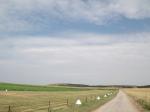
(Wenn Du auf dem Campingplatz angemeldet bist) entweder durch das Tor im rechten oberen Teil des Platzes Richtung "Top of the hill" - oder
zwischen dem ersten Campingplatz und dem zweiten dem Fussweg kurz vor dem zweiten Platz folgen (Auto an der Strasse stehen lassen). Am obersten Punkt des Hohlweges nach rechts bis zur Klippenkante. Dann links halten. Nach 50 m hast Du die ersten Auslegemöglichkeit erreicht (je nach Wind) Nach ca. 100 m gibt es auch einen Windsack der örtlichen Piloten. |
| Wegbeschreibung: |
Leichter Fussmarsch ca. 15 Min. |
| Sonstiges: |
|
Wissenswertes
| Seilbahn: |
Nein |
| Unterkunft: |
zahlreiche Hotels und Ferienwohnungen.
Am Strand gibt es einen grossen Wohnmobilstellplatz.
Zwei Campingplätze- |
| Anfahrt: |
Im Ort links am Meer entlang |
| Sonstiges: |
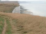
Einfache Landung am Strand (auf Flut achten) oder einfache Toplandung |
|


|
|
 |
|
0 Votes
|
2649 Hits
|
| [mnms] |
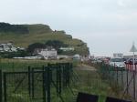
| Toplanding spot/ landingstrip, place to parc your car for take off |
|
|
|
|
 |
|
0 Votes
|
2487 Hits
|
| [mnms] |
| Because of the landwind that day I couldn't fly. nevertheless some pictures to indicate the start. to find the Start: in criel you go to the beach, then follow the sign gendarmerie 3 x, when you pass the building gendarmerie you have to turn to your right, you'll follow a small road up hill 1-2 km. on the cliffside you'll enter a landing strip, parc your car! on the left side of your strip you follow the path turn right after you pass the landingstrip, follow the path to the cliff on your right after the fence you are able to start. when you have taken of; on your right you can see criel plage |
|
|
Startplätze |
| Startplatz: |
Les Mouettes |
| GPS-Koordinaten: |
50° 01' 42'' N,01° 18' 02'' O |
| Startrichtung: |
NW |
| Schwierigkeit: |
mittel
|
| Höhe über NN: |
95 |
|
|
|
|
|
|
|
Landeplätze |
| Landeplatz: |
Criel Strand |
| GPS-Koordinaten: |
50° 01' 56'' N,01° 18' 34'' O |
| Schwierigkeit: |
mittel
|
| Höhe über NN: |
5 |
|
|
|
|
|
|
|
Umgebungskarte
Interaktive Karte
| Orte in der Nähe
C¡u Tr² (0 km)
Cúc Ph² (0 km)
Hµa C² (0 km)
Kim S² (0 km)
Lý D² (0 km)
Th² (0 km)
Toà Qu n Tr² (0 km)
X² (0 km)
9.9167 (0 km)
Xóm M²üi ’ (0 km)
Ëp Ð p Tr² (0 km)
Averittes Spring (0 km)
Bainbridge Plantation (0 km)
Big Shoal Village (0 km)
Brock Mill (0 km)
|
Fluggebiete in der Nähe (Radius: 50 km) |
|
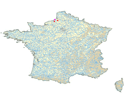
Europa » Frankreich » Haute-Normandie
Osmoy St Valery, 170 Meter

| Entfernung: | 25 km
|
|
Höhenuntersch.:
|
40
Meter
|
| Ort: | Osmoy St Valery
|
| Streckenflug: | Ja
|
| Startplatz: |
mittel
|
| Landeplatz: |
Keine Angabe
|
Für Gleitschirm- wie für Drachenflieger ein schönes Gelände, das für die Deltas ein bisschen leichter...
|
|
|
Europa » Frankreich » Haute-Normandie
Montfaucon, 0 Meter
| Entfernung: | 29 km
|
|
Höhenuntersch.:
|
80
Meter
|
| Ort: | Nesle Normandeuse
|
| Streckenflug: | Nein
|
| Startplatz: |
mittel
|
| Landeplatz: |
mittel
|
Nettes Gelände, das für Drachenflieger ebenso geeignet ist.
|
|
|
|
|
|
|  |
|