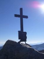
Keeskogel, 3200 Meter
|
|
| Talort: |
Hopffeldboden, 1000 Meter |
| Höhenunterschied: |
2200
Meter |
| Streckenflug: |
Ja |
| Seilbahn: |
Nein |
| Windenschlepp: |
Nein |
| Walk and Fly: |
Ja |
|
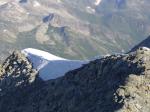
Same as Grossvenediger start in Hopffeldboden and leave the car there, take the cab to Material-lift and use the summer path up to Kürsinger Hütte (2558m, 1,5hrs walk). From the hut in the morning it is an easy 2 hrs climb to the top. Take off possible W to SW and O to NO. To reach the easterly take off you traverse 150m to the north and find a nicely sloped snow field (19.7.2006)
Reisebericht bei den Reiseberichten "Keeskogel/Schneekarspitze"
|
|
Flug
Takeoff and turn immediately back into Obersulzbachtal (alternatively fly down Untersulzbachtal and cross the ridge later)and fly down the valley to Hopffeldboden. Thermalling very well posssible at the valley facing sout east also earlier in the morning.
Schwierigkeit
alpine conditions
Besonderheiten und Webcam
traversing the ridge look out for cristals if interested - very nice examples everywhere
During the flight huge birds joined the thermal and came close to gain hight
Remote tour - you are on your own |
Walk and Fly
| Ausgangspunkt: |
very nice tour with brilliant view onto Grossvenediger. Realatively easy tour. |
| Wegbeschreibung: |
see charts |
| Sonstiges: |
|
|


|
|
 |
|
0 Votes
|
902 Hits
|
| [Axel7] |
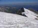
| ridge to Keeskogel take off - north of summit |
|
Mehr Bilder ansehen
|