Laspi - Crimea, Ukraine, 460 Meter
|
|
| Talort: |
Sevastopol, 0 Meter |
| Höhenunterschied: |
460
Meter |
| Streckenflug: |
Ja |
| Seilbahn: |
Nein |
| Windenschlepp: |
Nein |
| Walk and Fly: |
Nein |
| GPS Tal: |
44° 25' 41.8'' N,33° 42' 46'' O |
| GPS Berg: |
44° 25' 43.60'' N,33° 42' 35'' O |
|
|
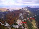
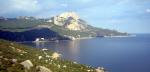
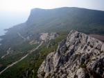
It's a flying site on the South Coast of Crimea. The take-off is situated above the bay of Laspi, in 10m under the highway. On the good sunny day it's easy to get 300-700 meters above the take-off and fly along the coast to Kush-Kaya mountain. Following its rocks you can fly 5-6 km from the take-off and back. Also there is possible XC-flights to the inner part of the Crimea. When an inversion is low, conditions can be rather turbulent.
|
|
Schwierigkeit
Landing area is on the roof of highway-tunnel, 15x180m, & along it electro-wires are stretched.
Alternative places for landing are small beaches, a Laspi's road or valleys behind the ridge of mountain.
Besonderheiten und Webcam
links:
http://www.crimea-paragliding.com/paraphotos.htm |
|

|