Mamancana, 365 Meter
|
|
| Talort: |
Santa Marta, 95 Meter |
| Höhenunterschied: |
270
Meter |
| Streckenflug: |
Keine Angabe |
| Seilbahn: |
Nein |
| Windenschlepp: |
Nein |
| Walk and Fly: |
Nein |
| GPS Tal: |
11° 08' 23.5'' N,74° 12' 38.9'' W |
| GPS Berg: |
11° 08' 49.3'' N,74° 12' 11.1'' W |
|
The paragliding season starts just a few days before christmas. At this time there will be instructors and locals around. During this time of the year the weather is quite hot and dry during the day and nice and cool in the evenings. There is definitely thermal activity to have some nice flights.
Contact Gerardo Muriel Serrano for any information needed in english and spanish:
gerencia@mamancana.com
Tel.:
4382737, 4382738 or 4382739
Cell.:
312 659 0044
|
|
Schwierigkeit
The landing can be a bit difficult for the inexperienced. Be careful of the many cactus and bushes around the landing strip.
Besonderheiten und Webcam
This place is under control of the local airport of Santa Marta. The paragliding instructors or the employees of the resort will clear you with the airport tower by radio or phone.
If you decide to fly in the morning, it's possible to land directly on the carribean beach. Later on you will have to land next to the Mamancana restaurant. |
Walk and Fly
| Ausgangspunkt: |
|
| Wegbeschreibung: |
|
| Sonstiges: |
|
Wissenswertes
| Fliegertreff: |
There is great food, drinks and music next to the landing strip. It's definitely worth it to watch the sun go down above the ocean from here while enjoying a cool drink! |
| Unterkunft: |
Check out the Mamancana web site under www.mamancana.com/links.php for hotels. The Zuana and the Irotama hotels are very nice. Talk with the park employees to organize something for you.
Weitere Informationen über die Flugseite bekommt ihr bei:
Paraworld Adventure Hostel Medellín
Florian Neuenschwander
Medellín-Colombia
Cel: (+57) 301 444 48 12
E-Mail: flo@paraworld.co |
| Anfahrt: |
Check out www.mamancana.com/location.php for directions. Basically you take the main highway from Barranquilla in the direction towards Santa Marta. About 1.5 miles after you pass the Santa Marta airport on the left you will see a small dirt road on the right at km 14, across from the Sintana high rise building, which will take you to Mamancana. The signs for the park are small - so look closely. |
|

 
|
|
 |
|
4 Votes
|
1803 Hits
|
| [marc1928] |
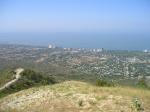
| This beautiful photo taken from the take off site gives you an idea of the beauty of the colombian carribean coast. Below you can see the Sintana building all the way on the left. This is where you enter the dirt road to get to Mamancana. |
|
|
|
|
 |
|
1 Votes
|
1135 Hits
|
| [marc1928] |
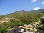
| This photo was taken from the Mamancana restaurant. Above you can see the take off spot. Right in front of the restaurant you can see the low landing strip. |
|
|
|
|
 |
|
1 Votes
|
1133 Hits
|
| [marc1928] |
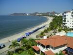
| Beautiful beaches everywhere! This is the landing beach for early morning flights from Mamancana. |
|
|