Bluff Hill, 106 Meter
|
|
| Talort: |
Napier, 4 Meter |
| Höhenunterschied: |
102
Meter |
| Streckenflug: |
Ja |
| Seilbahn: |
Nein |
| Windenschlepp: |
Nein |
| Walk and Fly: |
Ja |
|
Bluff Hill Lookout
Inland flying site on Hawjes Bay, very difficult for flying. There is a cliff starting place for the Paraglider that goes directly into the depth.
|
|
Besonderheiten und Webcam
For all information and special reports and flight rules please contact prior to flying [b]Airplay Paragliding[/b] ..... [url]airplay.co.nz[/url] or Mail under [url]enquiries@airplay.co.nz[/url]
[b]IMPORTANT[/b] Before flying please contact the Napier Airport Control Tower for information and flying permission under +64 6 835-7584 |
Walk and Fly
| Ausgangspunkt: |
|
| Wegbeschreibung: |
|
| Sonstiges: |
|
Wissenswertes
| Anfahrt: |
Hawkes is located directly on the coast and is situated along the National Couch Route, with a car it is under a half a days drive from all cities in New Zealand as is easily reached. Try to travel around the respective flight sites in this region (8 to be exact), please only with 4-wheel drive. |
| Sonstiges: |
Hawkes Bay in New Zealand is famous for its land, its wine and its Mediterranean lifestyle. |
|

|
Startplätze |
| Startplatz: |
Bluff Hill Lookout |
| GPS-Koordinaten: |
39° 28' 43.7'' S,176° 55' 4.7'' O |
| Startrichtung: |
N, O |
| Schwierigkeit: |
schwer
|
| Höhe über NN: |
106 |
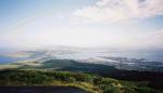
Startplatz nach Nord nur leicht abfallende Wiese, Foto
SP nach Ost, kurz klein mit Zaun zum überspringen !
Auffahrt via guter Teerstrasse, ohne Windsack,
Oben am Lookout viele Parkplätze 👍
.
|
|
|
|
|
|
Landeplätze |
| Landeplatz: |
Waterfront |
| Schwierigkeit: |
sehr leicht
|
| Höhe über NN: |
4 |
Der lange schmale Beach von Napier South,
ist am besten bei NO, auch am Besten zum soaren.
Siehe Foto
.
|
|
|
|
|
|
Umgebungskarte
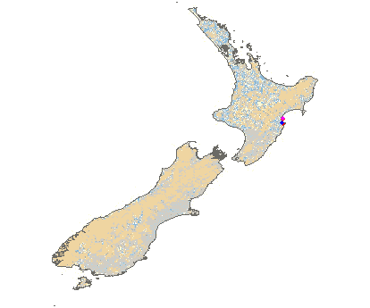
Interaktive Karte
| Orte in der Nähe
Napier City (0 km)
Napier (0 km)
Onekawa (0 km)
Ahuriri (1 km)
Port Ahuriri (1 km)
Westshore (3 km)
Greenmeadows (7 km)
Mast (7 km)
Awatoto (8 km)
Meeanee (8 km)
Puk-kura (8 km)
Bay View (8 km)
Taradale Town District (8 km)
Taradale (8 km)
Petane (9 km)
|
Fluggebiete in der Nähe (Radius: 50 km) |
|
Australien / Ozeanien » Neuseeland
Taits Beach, 20 Meter

| Entfernung: | 1 km
|
|
Höhenuntersch.:
|
24
Meter
|
| Ort: | Napier
|
| Streckenflug: | Ja
|
| Startplatz: |
leicht
|
| Landeplatz: |
leicht
|
Beautiful beach flying site on Hawkes Bay with many possibilities for both the beginner and experienced pilot. Hang Gliders fly here however,...
|
|
|
Australien / Ozeanien » Neuseeland
Kauahei, 408 Meter
| Entfernung: | 1 km
|
|
Höhenuntersch.:
|
408
Meter
|
| Ort: | Napier
|
| Streckenflug: | Ja
|
| Startplatz: |
schwer
|
| Landeplatz: |
schwer
|
This site is located on the southern end of the Kaokaoroa Range, directly north of Otane. It is possible for the Hang Glider to land above again.
|
|
|
Australien / Ozeanien » Neuseeland
Ocean Beach (Hawkes Bay), 61 Meter
| Entfernung: | 1 km
|
|
Höhenuntersch.:
|
61
Meter
|
| Ort: | Napier
|
| Streckenflug: | Ja
|
| Startplatz: |
mittel
|
| Landeplatz: |
mittel
|
A crazy beach flying site with a high cliff. Caution with the power poles and the model airplanes, that are always racing around here. Please...
|
|
|
|
Flugschulen in der Nähe (Radius: 50 km) |
|
Australien / Ozeanien » Neuseeland
Airplay Paragliding School - Hawkes Bay
Airplay Paragliding School
Hawkes Bay
Havelock North
www.airplay.co.nz
Entfernung: 21 km
4 Stunden von Wellington auf der nördlichen Insel von Neuseeland findet ihr in dem kleinen Ort Havelock North die Paragliding Schule "Airplay"....
|
|
|
|
|
|  |
|