Bonny Hills, 35 Meter
|
|
| Talort: |
Laurieton, 79 Meter |
| Höhenunterschied: |
-64
bis
-44
Meter |
| Streckenflug: |
Ja |
| Seilbahn: |
Nein |
| Windenschlepp: |
Nein |
| Walk and Fly: |
Nein |
|
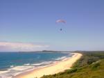
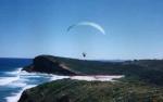
- SE: A flying site that everone enjoys. No hinderences or obstructions and is all round friendly to the pilot. Situated on the beach with light dunes, great wind, in a naturally beautiful place. Pure fun, you cant ask for much more.
- NE: Good but not so great for flying as from the SE side, but still enjoyable. Trouble arises from powerlines and windfarm, so please take care with this Dune\Sandhill flying site.
|
|
Besonderheiten und Webcam
| To fly at this site you must be a member of MID-NORTH COAST HG & PG ASSOCIATION. |
Wissenswertes
| Anfahrt: |
You will find this flying site near Laurieton, only 3.5 Hours from Sydney. This flying site is owned by MID-NORTH COAST HG & PG ASSOCIATION and they will glady help with any information required. |
|

 
|
|
 |
|
4 Votes
|
816 Hits
|
| Bonny Hills (NorthEast) |
| www.highadventureparagliding.com |
|
|
|
|
 |
|
4 Votes
|
722 Hits
|
| Bonny Hills (NorthEast) Para |
| www.highadventureparagliding.com |
|
|
Startplätze |
| Startplatz: |
Bonny Hills -Northeast |
| GPS-Koordinaten: |
31° 35' 40'' S,152° 50' 31'' O |
| Startrichtung: |
|
| Schwierigkeit: |
leicht
|
| Höhe über NN: |
15 |
|
|
|
| Startplatz: |
Bonny Hills -SouthEast |
| GPS-Koordinaten: |
31° 36' 27'' S,152° 50' 20'' O |
| Startrichtung: |
|
| Schwierigkeit: |
mittel
|
| Höhe über NN: |
35 |
|
|
|
|
|
|
|
Landeplätze |
| Landeplatz: |
Bonny Hills -Northeast |
| Schwierigkeit: |
leicht
|
| Höhe über NN: |
0 |
|
Toplanding or at beach below
|
|
| Landeplatz: |
Bonny Hills -Southeast |
| Schwierigkeit: |
Keine Angabe
|
| Höhe über NN: |
0 |
|
Toplanding or at beach below
|
|
|
|
|
|
Umgebungskarte
Interaktive Karte
| Orte in der Nähe
Camden Haven (0 km)
Laurieton (0 km)
Dunbogan (2 km)
Camden Haven (2 km)
North Brother (2 km)
North Haven (2 km)
Moores Island (4 km)
Rossglen (7 km)
Kew (8 km)
Kendall (10 km)
Herons Creek (10 km)
John (12 km)
Middle Brother (12 km)
Upsalls Creek (13 km)
Johns River (15 km)
|
Fluggebiete in der Nähe (Radius: 50 km) |
|
Australien / Ozeanien » Australien » New South Wales
North Brother Mountain, 550 Meter
Adopted by: [Vaudee]
| Entfernung: | 0 km
|
|
Höhenuntersch.:
|
471
Meter
|
| Ort: | Laurieton
|
| Streckenflug: | Ja
|
| Startplatz: |
leicht
|
| Landeplatz: |
leicht
|
Great flying site located on a mountain near the ocean. It can be dangerous to land when there is a strong sea breeze. Please do not land on the...
|
|
|
Australien / Ozeanien » Australien » New South Wales
Yarras Mountain, 750 Meter
Adopted by: [Alzom]
| Entfernung: | 0 km
|
|
Höhenuntersch.:
|
671
Meter
|
| Ort: | Laurieton
|
| Streckenflug: | Ja
|
| Startplatz: |
schwer
|
| Landeplatz: |
schwer
|
High flying directed to the north side, you will not find simple flying conditions at this site. Because the country side is large and wide this...
|
|
|
Australien / Ozeanien » Australien » New South Wales
Middle Brother Mountain, 600 Meter
Adopted by: [Vaudee]
| Entfernung: | 0 km
|
|
Höhenuntersch.:
|
521
Meter
|
| Ort: | Laurieton
|
| Streckenflug: | Ja
|
| Startplatz: |
leicht
|
| Landeplatz: |
leicht
|
Lovely green flying site. The best time for flying is between August and April. Take notice of the high trees, so not to be surprised when...
|
|
|
|
Flugschulen in der Nähe (Radius: 50 km) |
|
Australien / Ozeanien » Australien » New South Wales
High Adventure Air Park
High Adventure Air Park
Level 2, Suite 2, 65 Bold St.,
Laurieton, NSW 2443
www.highadventure.com.au/
Entfernung: 0 km
Allein die Homepage zeigt die Freude am fliegen! Hier gibt es alles, und noch viel mehr...Die aktuellen Termine sind auf der großartig gestalteten...
|
|
|
Australien / Ozeanien » Australien » New South Wales
Midcoast Microlights
Hacks Ferry Road,
Telegraph Point
Port Macquarie
New South Wales, Australia
www.midcoast.com.au/~microlights/
Entfernung: 27 km
Mark White hat in seinem Repertoire bei den motorisierten Drachenfliegern vom Scnhupperkurs bis zum Lizenzkurs alles im Angebot. Gerne stellt er...
|
|
|
|
|
|  |
|