Ocean Grove, 15 Meter
|
|
| Talort: |
Geelong, 2 Meter |
| Höhenunterschied: |
-275
Meter |
| Streckenflug: |
Ja |
| Seilbahn: |
Nein |
| Windenschlepp: |
Nein |
| Walk and Fly: |
Nein |
|
|
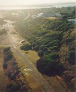
Lovley coastal flying site with sand dunes from Coastal Collendina to Point Lonsdale. The height of the dunes ranges from 2 to 15 Metres.
|
|
Flug
Because of the coasts conditions, that change quickly , beginners should forgo this site. Lovely view over the beach. In addition good thermal ratios that can bring you quickly upwards.
Schwierigkeit
[b]No top landings please![/b] (HG or PG) as this is well-used public path. It's a very quick walk up from the beach.
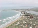
>> Landings are on the beach. Do not walk up the face of any dunes. Use the concrete ramp next to the Life Saving Club for access to cars, or the steps back up to launch. This site has been lost before, we do not want to lose it again.
Walk and Fly
| Ausgangspunkt: |
|
| Wegbeschreibung: |
|
| Sonstiges: |
More info here: [URL]www.vhpa.org.au/Sites/Ocean%20Grove.html[/URL]
(above info taken from this site) |
Wissenswertes
| Anfahrt: |
90km SW of Melbourne, via Geelong. From the Ocean Grove surf lifesaving club the takeoff is East on the old road directly below the Ocean Grove lookout. |
|


|
|
 |
|
0 Votes
|
600 Hits
|
| Ocean Grove Panorama |
| www.kingtidetownhouse.com.au |
|
|
Startplätze |
| Startplatz: |
Ocean Grove |
| GPS-Koordinaten: |
38° 16' 16'' S,144° 31' 19'' O |
| Startrichtung: |
|
| Schwierigkeit: |
mittel
|
| Höhe über NN: |
15 |
|
NO Toplanding!!
|
|
|
|
|
|
Landeplätze |
| Landeplatz: |
Ocean Grove |
| Schwierigkeit: |
mittel
|
| Höhe über NN: |
290 |
NO Toplanding!
[b]Do not walk up the face of any dunes.[/b] Use the concrete ramp next to the Life Saving Club for access to cars, or the steps back up to launch.
|
|
|
|
|
|
Umgebungskarte
Interaktive Karte
| Orte in der Nähe
Geelong (1 km)
Belmont (1 km)
Newtown and Chilwell (2 km)
Geelong West (3 km)
Fyansford (4 km)
Grovedale (5 km)
Marshalltown (5 km)
Marshall (5 km)
Norlane (6 km)
North Shore (7 km)
Ceres (7 km)
Moolap (8 km)
Batesford (9 km)
Waurn Ponds (9 km)
Corio (9 km)
|
Fluggebiete in der Nähe (Radius: 50 km) |
|
Australien / Ozeanien » Australien » Victoria
Barwon Heads, 15 Meter
Adopted by: [juerg]
| Entfernung: | 0 km
|
|
Höhenuntersch.:
|
13
Meter
|
| Ort: | Geelong
|
| Streckenflug: | Ja
|
| Startplatz: |
Keine Angabe
|
| Landeplatz: |
Keine Angabe
|
Coastal flying site near Geelong. This site has been closed since November 1999 due to dune erosion. (As of 2004!)
|
|
|
Australien / Ozeanien » Australien » Victoria
Clifton Springs, 0 Meter

| Entfernung: | 0 km
|
|
Höhenuntersch.:
|
-2
Meter
|
| Ort: | Geelong
|
| Streckenflug: | Ja
|
| Startplatz: |
Keine Angabe
|
| Landeplatz: |
Keine Angabe
|
Coastal site near Geelong. Since the middle of 1999 this site has be closed (until 2004).
|
|
|
Australien / Ozeanien » Australien » Victoria
Lovely Banks, 25 Meter
| Entfernung: | 10 km
|
|
Höhenuntersch.:
|
0
Meter
|
| Ort: | Lovely Banks
|
| Streckenflug: | Ja
|
| Startplatz: |
leicht
|
| Landeplatz: |
leicht
|
Flight field for Ultralights and Hang Gliders, that are brought with help of good winds upwards.
|
|
|
|
Flugschulen in der Nähe (Radius: 50 km) |
|
Australien / Ozeanien » Australien » Victoria
Adventure Airsports
225 the Esplanade
Torquay 3228
Victoria, Australia
www.adventureairsports.com.au
Entfernung: 20 km
Knapp 100 Kilometer südwestlich von Melbourne gelegen, präsentiert sich Torquay nicht nur als Surferparadies. In der sehr familiären Atmosphäre...
|
|
|
Australien / Ozeanien » Australien » Victoria
Melbourne Microlights
Melbourne Microlights
Point Cook Airfield
30 Bales Street
Mount Waverley
Vic, 3149.
www.users.bigpond.com/johnoliver/learnfly.htm
Entfernung: 48 km
Ausführliche Beschreibung der Kurse und Kosten. Da sich die Schule auf einem großen Flugfeld befindet, ist die motorisierte Variante des...
|
|
|
|
|
|  |
|