Leoncel - Grand Echaillon, 1447 Meter


Talort:
Leoncel
Höhe Talort:
909 Meter
Höhenunterschied:
312
Meter
Start Richtungen:
Seilbahn:
Nein
Streckenflug:
Ja
Soaring:
Ja
Windenschlepp:
Nein
Walk and Fly:
Ja
Ski and Fly:
Nein
Drachen:
Nein
UL:
Nein
GPS Tal:
GPS Berg:
Qualität Fluggebiet:
Qualität dieser Seite:
Statistik:
Adoption (User):
agatheman seit 26.04.2016
Zuletzt bearbeitet:
26.04.2016
Can fly with S, SW winds.
Regulations during hunting season.
Contact local club.
contact@tichodromes.org
Bewertung der Fluggebiets- und der Seitenqualität
Flug
Local or Cross country (better start earlier from nearby Col de la Bataille - E-SE start - for XC)
Hudge landing field
Schwierigkeit
Start slope is sideways. Mind your ankles.
Besonderheiten und Webcam
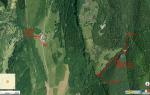
Acces without crossing the pastures. Follow the fence there is a ladder at the end to access the take-off.
See map |
Walk and Fly
Ausgangspunkt:
15' walk from parking
Wegbeschreibung:
Got to leoncel, follow "col de la bataille". Park 1km after "le grand echaillon" (road turns left, path goes right - valon de pissenible).
Turn right just before entering the small pissenible valley.
It goes up quite steep. You are in a wood. Just before exiting the wood and entering the pasture, turn left and follow the fence. Until you find the ladder.
Sonstiges:
Soaring
Soaringbedingungen:
Top landings paradise
Wissenswertes
Fliegertreff:
Leoncel downtown
Anfahrt:
Valence, Chabeuil, Peyrus, Leoncel
Startplätze
Startplatz:
Grand Echaillon
GPS-Koordinaten:
Startrichtung:

S SW Schwierigkeit:
mittel
Höhe über NN:
1221
End of large pasture.
Slope goes sideways
|
Landeplätze
Landeplatz:
Leoncel
GPS-Koordinaten:
Schwierigkeit:
sehr leicht
Höhe über NN:
909
Frankfurt airport is smaller. But prefer to land close to the windsack.
|
Download: Google Earth Dateien für Fluggebiet und Flugdaten (IGC, OLC)
Download: Google Earth Dateien (KML-Format), Flugdaten (IGC Format)
Die letzten 3 Flüge
Leider keine OLC Daten vorhanden.
Flugdaten von www.paraglidingforum.com
Leider keine OLC Daten von www.paraglidingforum.com vorhanden.
Alle Fluggebiete und Flugschulen in der Nähe anzeigen