Wonderland Lake, 1800 Meter
          
Talort:
Boulder
Höhe Talort:
1600 Meter
Höhenunterschied:
200
bis
305
Meter
Start Richtungen:
Seilbahn:
Nein
Streckenflug:
Nein
Soaring:
Keine Angabe
Windenschlepp:
Nein
Walk and Fly:
Nein
Ski and Fly:
Nein
Drachen:
Keine Angabe
UL:
Keine Angabe
Google Maps:
Qualität Fluggebiet:
Qualität dieser Seite:
Statistik:
Adoption (User):
-
Zuletzt bearbeitet:
14.08.2018
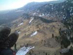
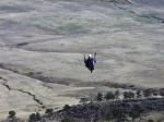
Wonderland Lake offers not only outstanding Ridge Soaring potential, but above all its one of the few open zones around Boulder.
Bewertung der Fluggebiets- und der Seitenqualität
Flug
The eastward directed hill offers three heights from which one can start in corresponding winds.
Schwierigkeit
All pilots must abide by the rules of the RMHGA & City Of Boulder Open Space and Mountain Parks read and accept: http://www.ci.boulder.co.us/openspace/
Wissenswertes
Sonstiges:
Wonderland Lake bietet nicht nur hervorragendes Ridge Soaring Potential, das Gebiet ist vor allem eines der wenigen offenen um Boulder.
Der ostwärts gewandte Hügel bietet drei Höhen, von denen man bei entsprechenden Winden starten kann.
Alle Flieger müssen sich mit den Regeln der RMHGA & City Of Boulder Open Space and Mountain Parks vetraut machen und diese akzeptieren: http://www.ci.boulder.co.us/openspace/
Startplätze
Startplatz:
Upper Launch
Startrichtung:
Schwierigkeit:
leicht
Höhe über NN:
1800
Vom Parkplatz Locust Street/6th Street etwa eine ¾ Meile Fußweg.
Startplatz:
Wonderland Hills
GPS-Koordinaten:
Startrichtung:

O Schwierigkeit:
mittel
Höhe über NN:
1905
|
Landeplätze
Landeplatz:
Landing Zone
Schwierigkeit:
leicht
Höhe über NN:
1600
|
Download: Google Earth Dateien für Fluggebiet und Flugdaten (IGC, OLC)
Download: Google Earth Dateien (KML-Format), Flugdaten (IGC Format)
Die letzten 3 Flüge
Leider keine OLC Daten vorhanden.
Flugdaten von www.paraglidingforum.com
Leider keine OLC Daten von www.paraglidingforum.com vorhanden.
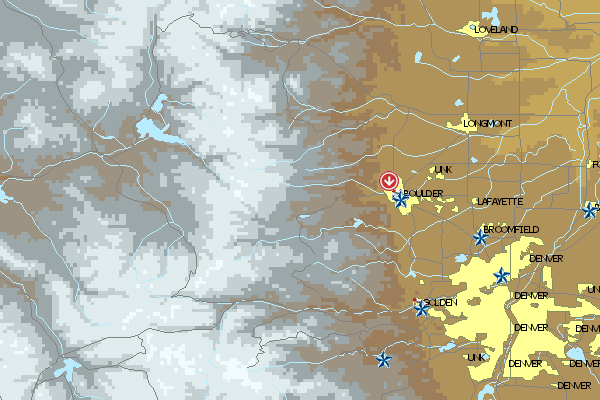
Umgebungskarte
  Fluggebiet  Flugschule  Aktuelle Position |
Fluggebiete in der Nähe (Radius: 50 km)
Nordamerika » USA » Colorado
Entfernung:
5 km
Höhenuntersch.:
200
Meter
Ort:
Boulder
Streckenflug:
Nein
Startplatz:
Keine Angabe
Landeplatz:
Keine Angabe
Start Richtungen:
Momentarily only the Coyote, that live in the area in large numbers, howl here: Dakota Ridge is closed. When one can fly again, you will find the cliff in the vicinity of the parking lot Broadway 28thStreet – where it is another 45 minute walk away.
Nordamerika » USA » Colorado
Entfernung:
5 km
Höhenuntersch.:
180
Meter
Ort:
Boulder
Streckenflug:
Nein
Startplatz:
Keine Angabe
Landeplatz:
Keine Angabe
Start Richtungen:

|
17.01.2006
|
 |
|
0 Votes
|
1357 Hits
|
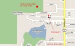
| [Oliver Voss] | | www.parasoftparagliding.com | | So kommt ihr hin. |
|
You can begin the thermic hunt from three launch sites. North Boulder is not difficult and can be flown all year round.
Nordamerika » USA » Colorado
Entfernung:
5 km
Höhenuntersch.:
150
Meter
Ort:
Boulder
Streckenflug:
Nein
Startplatz:
Keine Angabe
Landeplatz:
Keine Angabe
Start Richtungen:
|
|
02.12.2004
|
 |
|
0 Votes
|
608 Hits
|
| www.parasoftparagliding.com |
|
Also the „Beech Aircraft Launch“ named cliff is ideal for Soaring- and Thermic flights. To be sure also here also check the typical Boulder restriction: passing closed. If it changes, park in the Old Stage Road, then 15 min by foot.
Flugschulen in der Nähe (Radius: 50 km)
Nordamerika » USA » Colorado
Flugschulleiter Bill Laurence ist stolzer Träger des "Diamond Safety Award". Ihr begebt euch also in sichere Hände. Neben dem üblichen Programm...
Nordamerika » USA » Colorado
Peak to Peak Paragliding
1035 Utica Avenue
Boulder, Colorado 80304
Entfernung: 6 km
Kay Tauscher leitet diese Schule in Boulder. Wäre schön wenn er im Internet weitere Informationen preisgeben würde.
Nordamerika » USA » Colorado
Parasoft ist eine sehr professionelle Schule, wie man schon an der Website erkennen kann. Granger Banks bietet ein vielfältiges Angebot und...
Alle Fluggebiete und Flugschulen in der Nähe anzeigen
|