|
|
Nordamerika » USA » Idaho
Ben´s Crown Inn, 1000 Meter
|
Höhenuntersch.:
|
150
Meter
|
| Ort: | Boise
|
| Streckenflug: | Nein
|
| Startplatz: |
Keine Angabe
|
| Landeplatz: |
Keine Angabe
|
| Start Richtungen: |

|
This site, also known as 'Cobb's Knob' is located directly near Boise. Drive five miles on the Warm Springs Road towards Bens Crown Inn, then take Teresa Drive until Eastwood Place. Park and make the rest of the way by foot.
|
|
|
|
|
Nordamerika » USA » Idaho
Big Southern Butte, 2200 Meter
|
Höhenuntersch.:
|
700
Meter
|
| Ort: | Atomic City
|
| Streckenflug: | Nein
|
| Startplatz: |
Keine Angabe
|
| Landeplatz: |
Keine Angabe
|
| Start Richtungen: |
|
The ash cone in Snake River Plan is an alternative to King Mountain.
|
|
|
|
|
Nordamerika » USA » Idaho
Greenhorn, 2320 Meter
|
Höhenuntersch.:
|
540
Meter
|
| Ort: | Ketchum
|
| Streckenflug: | Nein
|
| Startplatz: |
Keine Angabe
|
| Landeplatz: |
Keine Angabe
|
| Start Richtungen: |
|
This mountain is located six miles south from Ketchum. Its reachable with all-wheel-drive with the dry months from May-Novemeber.
|
|
|
|
|
Nordamerika » USA » Idaho
Harrison, 1000 Meter
|
Höhenuntersch.:
|
300
Meter
|
| Ort: | Harrison
|
| Streckenflug: | Nein
|
| Startplatz: |
Keine Angabe
|
| Landeplatz: |
Keine Angabe
|
| Start Richtungen: |
|
Lovely flights over the lake, around which its also perfect for camping.
|
|
|
|
|
Nordamerika » USA » Idaho
Heavens Gate, 900 Meter
|
Höhenuntersch.:
|
300
Meter
|
| Ort: | Riggins
|
| Streckenflug: | Nein
|
| Startplatz: |
Keine Angabe
|
| Landeplatz: |
Keine Angabe
|
| Start Richtungen: |
|
The Seven Devils Mountains separate the Salmon and Snale River from one another. Alone the way up here is an adventure, the flights however are unforgettable.
|
|
|
|
|
Nordamerika » USA » Idaho
John Day Mountain, 1890 Meter
|
Höhenuntersch.:
|
1340
Meter
|
| Ort: | Lucile
|
| Streckenflug: | Nein
|
| Startplatz: |
Keine Angabe
|
| Landeplatz: |
Keine Angabe
|
| Start Richtungen: |
|
This cliff is located in the heart of Idaho inbetween the Salmon and Snake Rivers. The high mountain and soft hills stamp this area into your heart.
|
|
|
|
|
Nordamerika » USA » Idaho
Jumpoff, 1650 Meter
|
Höhenuntersch.:
|
170
Meter
|
| Ort: | Howe
|
| Streckenflug: | Nein
|
| Startplatz: |
Keine Angabe
|
| Landeplatz: |
Keine Angabe
|
| Start Richtungen: |
|
Jumpoff is located on the backside of the Lost River Valley over the town of Howe.
|
|
|

|
26.07.2014
|
 |
|
20 Votes
|
1083 Hits
|
| [taggi] | | lower und upper TO |
|
|
Nordamerika » USA » Idaho
King Mountain, 2430 Meter
|
Höhenuntersch.:
|
460
bis
750
Meter
|
| Ort: | Moore (Arco)
|
| Streckenflug: | Ja
|
| Startplatz: |
leicht
|
| Landeplatz: |
leicht
|
| Start Richtungen: |

|
King Mountain ist Ausgangspunkt für grosse Strecken Richtung N und O. Oft ist die Basis über 18'000ft.
Wegen der zT starken Winde eher ein Gebiet für HG.
|
|
|
|
|
Nordamerika » USA » Idaho
Melba, 950 Meter
|
Höhenuntersch.:
|
100
Meter
|
| Ort: | Boise
|
| Streckenflug: | Nein
|
| Startplatz: |
Keine Angabe
|
| Landeplatz: |
Keine Angabe
|
| Start Richtungen: |
|
This cliff impresses, however not because of its height, it offers however with a length on only one mile, flight fun.
|
|
|
|
|
Nordamerika » USA » Idaho
Mindbender, 2800 Meter
|
Höhenuntersch.:
|
1100
Meter
|
| Ort: | Ketchum
|
| Streckenflug: | Nein
|
| Startplatz: |
Keine Angabe
|
| Landeplatz: |
Keine Angabe
|
| Start Richtungen: |
|
This northern site is nothing for weak nerves. The way is not easy and without a knowing local accompainment it is very difficult to find.
|
|
|

|
23.07.2016
|
 |
|
11 Votes
|
783 Hits
|
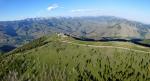
| [taggi] | | Mt.Baldy (looking east) |
|
|
Nordamerika » USA » Idaho
Mt. Baldy, 2800 Meter
|
Höhenuntersch.:
|
960
Meter
|
| Ort: | Ketchum, Sun Valley
|
| Streckenflug: | Ja
|
| Startplatz: |
mittel
|
| Landeplatz: |
leicht
|
| Start Richtungen: |

|
Der Baldy ist ein ganzjähriges Vergnügungsgebiet für Flieger. Mit den diversen Lifts könnt ihr euch bequem hinaufbringen lassen, um dann von einem der Startplätze zu soaren.
-----------------------------------
The Baldy is an all-year amusement zone for flyers. With the...
|
|
|
|
|
Nordamerika » USA » Idaho
Pickle Butte, 920 Meter
|
Höhenuntersch.:
|
150
Meter
|
| Ort: | Nampa
|
| Streckenflug: | Nein
|
| Startplatz: |
Keine Angabe
|
| Landeplatz: |
Keine Angabe
|
| Start Richtungen: |
|
This cliff is located south of Nampa. Drive along the Highway 45 to the Missouri Road, continue until the end and then left on the sand road out.
|
|
|
|
|
Nordamerika » USA » Idaho
Sky Ridge, 2200 Meter
|
Höhenuntersch.:
|
550
Meter
|
| Ort: | Hailey
|
| Streckenflug: | Nein
|
| Startplatz: |
Keine Angabe
|
| Landeplatz: |
Keine Angabe
|
| Start Richtungen: |
|
In the meager and quite dry zone 17 miles southwest of Ketchum you will find the 3 miles of long Sky Ridge.
|
|
|
|
|
Nordamerika » USA » Idaho
Squaw Mountain, 1740 Meter
|
Höhenuntersch.:
|
900
Meter
|
| Ort: | Boise
|
| Streckenflug: | Nein
|
| Startplatz: |
Keine Angabe
|
| Landeplatz: |
Keine Angabe
|
| Start Richtungen: |
|
The Squaw is well the most profitable flying area around Boise: finally a proper mountain.
|
|
|
|
|
Nordamerika » USA » Idaho
tbd, 0 Meter
|
Höhenuntersch.:
|
0
Meter
|
| Ort: | tbd
|
| Streckenflug: | Nein
|
| Startplatz: |
Keine Angabe
|
| Landeplatz: |
Keine Angabe
|
| Start Richtungen: |
|
Doublette!
|
|
|
|
|
Nordamerika » USA » Idaho
Warm Springs, 1400 Meter
|
Höhenuntersch.:
|
600
Meter
|
| Ort: | Boise
|
| Streckenflug: | Nein
|
| Startplatz: |
Keine Angabe
|
| Landeplatz: |
Keine Angabe
|
| Start Richtungen: |
|
This site is located one hour away from Boise. You will find it over the Warm Springs Road and Highway 21 in the direction of Idaho City. Before that turn onto the Grimes Creek Road, which is a little sandy. After 8 miles you will reach the landing area. When you follow the road further...
|
|
|